


Colorado State Almanac: Facts and Figures
Quick Facts, Figures, and Overview of the State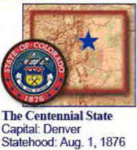 of Colorado
Colorado is one of the Mountain states of the US. The State of Colorado shares its northern border with Wyoming and Nebraska, eastern border with Kansas and Nebraska, southern border with New Mexico and Oklahoma and western border with Utah. Colorado's name, has its origin in the Spanish language, as the word for "ruddy"or "red."
By the 1990s, Colorado had a diversified economy with substantial light-industrial development and a growing tourist industry based on its scenic and recreational attractions. Colorado's economy is now driven by the service industries, including medical providers and other business and professional services. Colorado's economy also has a strong manufacturing base. The primary manufactures are food products, printing and publishing, machinery, and electrical instruments. The state is also a communications and transportation hub for the Rocky Mountain region.
The farm industry, which is primarily concentrated in livestock, is also an important element of the state's economy. The primary crops in Colorado are corn, hay, and wheat.
Colorado Almanac: Facts & Figures on Colorado |
|
|---|---|
| Official Name | Colorado |
| Capital | Denver |
| Nicknames | Centennial State ... and more |
| Motto | Nil Sine Numine (Nothing without providence) |
| Location Region |
39.76803 N, 104.87265 W Great Plains Rocky Mountains Southwestern |
| Constitution Ratified | 1876 |
| Statehood | August 01, 1876 38th state |
| Population | 5,029,196 (2010) 41.47 sq. mi. 24th |
| Largest City (by population) |
10 largest cities (2010):Denver, 600,158; Colorado Springs, 416,427; Aurora, 325,078; Fort Collins,
143,986; Lakewood, 142,980; Thornton, 118,772; Westminster, 106,114; Arvada, 106,433 Pueblo, 106,595; Centennial, 100,377 |
| Bordering States | North: Wyoming and Nebraska East: Nebraska and Kansas South: Oklahoma and New Mexico West: Utah |
| Major Industry | agriculture (wheat, cattle, sheep), tourism (especially skiers), mining (gold, silver), oil, finance, and manufacturing |
| Major Rivers | Colorado River, Rio Grande, Arkansas River, South Platte River |
| Major Lakes | Grand Lake, Blue Mesa Reservoir, John Martin Reservoir |
| Colorado Counties | 64 Counties in Colorado |
| Largest County (by population) |
El Paso County 622,263 (2010) 153 sq. mi. |
| Largest County (by area) |
Las Animas County 4,773 sq. mi. |
| State forests | 1 (71,000 ac.) |
| State parks | 44 (160,000 ac.) |
| Electoral Votes | 9 (as of the 2004 Presidential Election) |
| US Congress | 2 Senators; 7 Representatives |
| Time Zone | Mountain Standard Time |
| Zip Codes | NANPA |
| State Quick Facts | Census Bureau Quick Facts |
Colorado Climate and Weather |
|
|---|---|
| Colorado weather can change drastically over a day, and can see all weather conditions throughout the year. It's not uncommon to have wide temperature swings from one day to the next (40 degrees F!) or even in a summer day (a thunderstorm can drop the temperature30 degrees in 15 minutes). Colorado is a high desert, and typically sees less moisture as a result. Also, it's a little known secret that Colorado has more sunny days per year than Florida. | |
| Highest Temperature | 118 degrees Jul. 11, 1888 - Bennett. |
| Lowest Temperature | -61 degrees Feb. 1, 1985 - Maybell. |
| Avg. Temp: High - Low |
98.8 degrees 36.8 degrees |
Colorado Points of Interest |
|
| Some of the most recognizable and stunning vacation destinations on the planet are located in the Rocky Mountains of Colorado, including the world-class ski resorts of Aspen, Breckenridge, Durango, Steamboat Springs and Vail. Denver's metropolitan area features professional sports, numerous shopping venues and high-quality museums and theaters. The main tourist attractions in the state include Rocky Mountain National Park, Curecanti National Recreation Area, Mesa Verde National Park, the Great Sand Dunes and Dinosaur National Monuments, Colorado National Monument, and the Black Canyon of the Gunnison National Monument.- to name but a few. | |
Colorado Highest, Lowest, and Mean Elevations (Feet) |
|
| Mean Elevation: 6,800 feet | |
| Highest Point: Mt. Elbert: 14,433 feet
|
|
| Lowest Point: | Arkansas River 3,350 feet |
Colorado Land Area (Square Miles) |
|
| Geographic Center | In Park County, 30 mi. NW of Pikes Peak Longitude: 105°38.5'W Latitude: 38°59.9'N |
| Total Area | 104,093.57 sq. mi. 8th |
| Land Area | 103,717.53 sq. mi. 99.64% |
| Water Area | 376.04 sq. mi. 0.36% |
| Forested Land Area | 32.1% |
| Dimensions (Length - Width) |
380 miles - 280 miles |
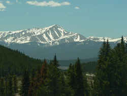 Mt. Elbert at 14,433 ft. elevation
is the highest point in Colorado. It is the second highest mountain in the adjacent 48 states. (Mount Whitney, 14,494 ft., is highest). Elbert is
a massive mountain, easily ascended by its long, smooth ridges. Samuel H. Elbert (1833-1899) was an outstanding and widely known civic leader in
the Territory and State of Colorado. Mt. Elbert, Elbert County, and the town of Elbert, Colorado were all named in his honor.
Mt. Elbert at 14,433 ft. elevation
is the highest point in Colorado. It is the second highest mountain in the adjacent 48 states. (Mount Whitney, 14,494 ft., is highest). Elbert is
a massive mountain, easily ascended by its long, smooth ridges. Samuel H. Elbert (1833-1899) was an outstanding and widely known civic leader in
the Territory and State of Colorado. Mt. Elbert, Elbert County, and the town of Elbert, Colorado were all named in his honor.Adams, Alamosa, Arapahoe, Archuleta, Baca, Bent, Boulder, Broomfield City and, Chaffee, Cheyenne, Clear Creek, Conejos, Costilla, Crowley, Custer, Delta, Denver, Dolores, Douglas, Eagle, El Paso, Elbert, Fremont, Garfield, Gilpin, Grand, Gunnison, Hinsdale, Huerfano, Jackson, Jefferson, Kiowa, Kit Carson, La Plata, Lake, Larimer, Las Animas, Lincoln, Logan, Mesa, Mineral, Moffat, Montezuma, Montrose, Morgan, Otero, Ouray, Park, Phillips, Pitkin, Prowers, Pueblo, Rio Blanco, Rio Grande, Routt, Saguache, San Juan, San Miguel, Sedgwick, Summit, Teller, Washington, Weld, Yuma

