


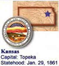
Kansas State Almanac: Facts and Figures
Quick Facts, Figures, and Overview of the State of Kansas
Kansas is one of the West North Central states of the US The state is situated at the geographical center of the 48 conterminous states. The state of Kansas comprises of westward dipping sedimentary rocks. The western part of the state lies on the great central plain area of the United States. Kansas is bordered by Nebraska on the north; Missouri on the east; Oklahoma on the south; and Colorado on the west. Kansas' name origin was from 'The Kansas River' that was named by the French after the Kansas, Omaha, Kaw, Osage and Dakota Sioux Indian word "KaNze" meaning, in the Kansas language "south wind."
Kansas known as an agricultural state, Kansas had, by the 1990s, a well-diversified economy, dominated by service industries and manufacturing. Kansas remains, nonetheless, one of the leading agricultural states. Today, wheat fields, oil-well derricks, herds of cattle, and grain-storage elevators are chief features of the Kansas landscape. A leading wheat-growing state, Kansas also raises corn, sorghum, oats, barley, soybeans, and potatoes. Kansas stands high in petroleum production and mines zinc, coal, salt, and lead. It is also the nation's leading producer of helium.
Wichita is one of the nation's leading aircraft-manufacturing centers, ranking first in production of private aircraft. Kansas City is an important
transportation, milling, and meat-packing center.
Kansas Almanac: Facts and Figures on Kansas |
|||
|---|---|---|---|
| Official Name | Kansas | ||
| Capital | Topeka | ||
| Nicknames | Sunflower State; Jayhawk State ...and more | ||
| Motto | Ad Astra per Aspera (To the stars through difficulties) | ||
| Location Region |
39.03790 N, 095.69199 W Great Plains Midwest Northwestern |
||
| Constitution Ratified | 1859 | ||
| Statehood | January 29, 1861 34th state |
||
| Population | 2,688,418 32.86 32nd |
||
| Largest City (by population) |
10 largest cities (2010): Wichita, 382,368; Overland Park, 173,372; Kansas City, 145,786; Topeka, 127,473; Olathe, 125,872; Lawrence, 87,643; Shawnee, 62,209; Manhattan, 52,281; Lenexa, 48,190; Salina, 47,707 | ||
| Bordering States | North: Nebraska (Missouri River forms the Northeastern boundary) East: Missouri South: Oklahoma West: Colorado |
||
| Major Industry | agriculture (wheat and other grains), aircraft manufacturing, automobile manufacturing | ||
| Major Rivers | Kansas River, Republican River, Smoky Hill River, Arkansas River, Missouri | ||
| Major Lakes | Tuttle Creek Reservoir, Cheney Reservoir, Waconda Lake | ||
| Kansas Counties | 93 Counties in Kansas | ||
| Largest County (by population) |
Johnson County 544,179 (2010) 457 sq. mi. |
||
| Largest County (by area) |
Butler County 1,428 sq mi. |
||
| State parks | 24 | ||
| Electoral Votes | 6 | ||
| US Congress | 2 Senators; 4 Representatives | ||
| Time Zone | Central Standard Time | ||
| Zip Codes | NANPA | ||
| State Quick Facts | Census Bureau Quick Facts | ||
Kansas Climate and Weather |
|
|---|---|
| Kansas weather is variable and unpredictable. Winter blizzards,
violent windstorms, and heavy rains are common throughout the state, and the continental climate (on occasion) produces rapid temperature extremes.
Generally here the summers are quite warm, the winters are mild, and the humidity is on the moderate side. Early evening thunderstorms are common in summer, and tornados strike the state on a regular basis as Kansas is in America's Tornado Alley. January is the coldest month, with average high temperatures near 25 degrees. July is the warmest month, with average high temperatures near 80 degrees. Much hotter summers and harsh, cold winters are not uncommon. Annual precipitation amounts range from 30 - 40 inches in the east, while drier conditions are common in the west. |
|
| Highest Temperature | 121 degrees July 24, 1936 - Alton |
| Lowest Temperature | -40 degrees February 13, 1905 - Lebanon |
| Avg. Temp: High - Low |
92.9 degrees 15.7 degrees |
Kansas Points of Interest |
|
| Amelia Earhart Museum in Atchison; Eisenhower Center in Abilene; State Capital Building in Topeka; Kansas History Center at Topeka, the Eisenhower boyhood home and the Eisenhower Memorial Museum and Presidential Library at Abilene, John Brown's cabin at Osawatomie, re-created Front Street in Dodge City, Fort Larned (an important military post on the Santa Fe Trail), Fort Leavenworth, Fort Riley, the western history of Dodge City, and the state's largest city, Wichita, to name but a few. | |
Kansas Highest, Lowest, and Mean Elevations (Feet) |
|
| Mean Elevation: 2,000 feet | |
| Highest Point: Mt. Sunflower: 4,039 feet
|
|
| Lowest Point: | Verdigris River 679 feet |
Kansas Land Area (Square Miles) |
|
| Geographic Center | In Barton County, 15 mi. NE of Great Bend Longitude: 98°41.9'W Latitude: 38°29.9'N |
| Total Area | 82,276.84 15th |
| Land Area | 81,814.88 sq. mi. 99.44% |
| Water Area | 461.96 sq. mi. 0.56% |
| Forested Land Area | 3% |
| Dimensions (Length - Width) |
400 miles - 210 miles |
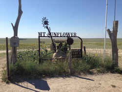 At 4,039 feet above sea level, Mount
Sunflower is the highest point in Kansas. Located in Wallace County, just east of the Kansas/Colorado border, Mount Sunflower is more than 3,300
feet above the state's topographic low point in Montgomery County in southeastern Kansas. Much of Mount Sunflower's elevation is due to the uplift
of the Rocky Mountains to the west.
At 4,039 feet above sea level, Mount
Sunflower is the highest point in Kansas. Located in Wallace County, just east of the Kansas/Colorado border, Mount Sunflower is more than 3,300
feet above the state's topographic low point in Montgomery County in southeastern Kansas. Much of Mount Sunflower's elevation is due to the uplift
of the Rocky Mountains to the west.Allen, Anderson, Atchison, Barber, Barton, Bourbon, Brown, Butler, Chase, Chautauqua, Cherokee, Cheyenne, Clark, Clay, Cloud, Coffey, Comanche, Cowley, Crawford, Decatur, Dickinson, Doniphan, Douglas, Edwards, Elk, Ellis, Ellsworth, Finney, Ford, Franklin, Geary, Gove, Graham, Grant, Gray, Greeley, Greenwood, Hamilton, Harper, Harvey, Haskell, Hodgeman, Jackson, Jefferson, Jewell, Johnson, Kearny, Kingman, Kiowa, Labette, Lane, Leavenworth, Lincoln, Linn, Logan, Lyon, Marion, Marshall, McPherson, Meade, Miami, Mitchell, Montgomery, Morris, Morton, Nemaha, Neosho, Ness, Norton, Osage, Osborne, Ottawa, Pawnee, Phillips, Pottawatomie, Pratt, Rawlins, Reno, Republic, Rice, Riley, Rooks, Rush, Russell, Saline, Scott, Sedgwick, Seward, Shawnee, Sheridan, Sherman, Smith, Stafford, Stanton, Stevens, Sumner, Thomas, Trego, Unified Govt. of Wyandotte, Wabaunsee, Wallace, Washington, Wichita, Wilson, Woodson

