


Maine State Almanac: Facts and Figures
Quick Facts, Figures, and Overview of the State of Maine

Maine is one of the New England states of the US West Quoddy Head, a small peninsula in the SE, is the easternmost point of land of the US. Maine is the 41st most populous state of the 50 US states. Maine is a state in the New England region of the northeastern United States, bordered by the Atlantic Ocean to the east and south; New Hampshire to the west; the Canadian provinces of Quebec to the northwest; and New Brunswick to the northeast. Maine is both the easternmost and northern most point of New England region located in the northeastern part of United States. Maine's name was first used to distinguish the mainland from the offshore islands. It has been considered a compliment to Henrietta Maria, queen of Charles I of England. She was said to have owned the province of Mayne in France.
Maine produces 98% of the nation's low-bush blueberries. Farm income is also derived from apples, potatoes, dairy products, and vegetables, with poultry and eggs the largest selling item. Manufacturing began to play a leading role in the Maine economy in the late 19th century. In the early 1990s the chief fabricated items were forest products, transportation equipment, electronic items, leather goods, apparel and textiles, and processed food. Tourism also is an important industry, and the state's extensive fisheries are noted for producing lobsters.
Maine Almanac: Facts and Figures on Maine |
|||
|---|---|---|---|
| Official Name | Maine | ||
| Capital | Augusta | ||
| Nicknames | Pine Tree State ...and more | ||
| Motto | Dirigo (I direct) | ||
| Location Region |
44.33064 N, 069.72971 W New England Northeastern |
||
| Constitution Ratified | 1820 | ||
| Statehood | March 15, 1820 23rd state |
||
| Population | 1,328,361 (2010) 41.31 sq. mi. 40th |
||
| Largest City (by population) |
10 largest cities (2010): Portland, 66,194; Lewiston, 36,592; Bangor, 33,039; South Portland, 25,002; Auburn, 23,055; Biddeford, 21,277; Sanford, 20,792; Brunswick, 20,278; Augusta, 19,136; Scarborough, 18,919 | ||
| Bordering States | North and East: Canadian province of New Brunswick (Saint John and Saint Francis rivers form part of the Northern
boundary) South: Gulf of Maine (an arm of the Atlantic Ocean) (Saint Croix River forms part of the Southeastern boundary) (Salmon Falls River forms part of the Southwestern boundary) West: New Hampshire North West: Quebec Province Coastline: 228 mi. |
||
| Major Industry | agriculture (especially potatoes), shipbuilding, fishing (especially lobsters), footwear, machinery, electronics, tourism | ||
| Major Rivers | Androscoggin River, Kennebec River, Penobscot River, St. John River | ||
| Major Lakes | Lake Moosehead, Richardson Lakes | ||
| Maine Counties | 16 Counties in Maine | ||
| Largest County (by population) |
Cumberland County 281,674 (2010 836 sq. mi. |
||
| Largest County (by area) |
Aroostook County 6,672 sq. mi. |
||
| State forests | 1 (21,000 ac.) | ||
| State parks | 30+ | ||
| State historic sites | 18 (403 ac.) | ||
| Time Zone | Eastern Standard Time | ||
| Zip Codes | NANPA | ||
| State Quick Facts | Census Bureau Quick Facts | ||
Maine Climate and Weather |
||
|---|---|---|
| Maine's climate is highly changeable -- it can go from sunny to stormy in short order. Generally, summers are cool, with highs in the upper 70s or low 80s F/24-27 C. Some summers have days that get above 90 F/32 C; some don't. Interior areas experience a greater range of temperatures in the summer, with some nights in northern areas at or near freezing. Winters in Maine are cold but not frigid. January temperatures range 11 to 31 F/-12 to -1 C along the coast and 1 to 19 F/-16 to -7 C inland. Snow melts frequently along the coast. | ||
| Highest Temperature | 105 degrees July 10, 1911 - North Bridgton |
|
| Lowest Temperature | -48 degrees January 19, 1925 - Van Buren |
|
| Avg. Temp: High - Low |
78.9 degrees - 11.9 degrees | |
Maine Points of Interest |
||
|
Maine offers countless
things to see and do, regardless of the time of year. Popular outdoor activities include fishing, kayaking, sailing, skiing and snowboarding.
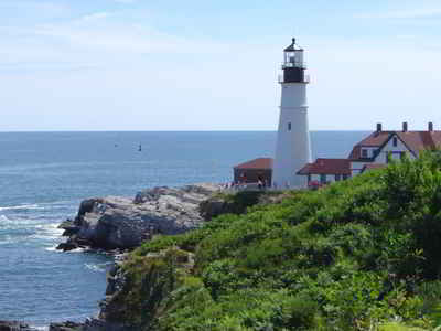
In addition, visitors will thoroughly enjoy Maine's historic sites, homes and museums. Some of the state's busiest attractions include Acadia National Park, coastal fishing villages and lighthouses, Baxter State Park, the historic buildings of Augusta, Bar Harbor, Allagash National Wilderness Waterway, the Wadsworth-Longfellow House in Portland, Roosevelt Campobello International Park, and the St. Croix Island National Monument. and much, much more. |
||
Maine Highest, Lowest, and Mean Elevations (Feet) |
||
| Mean Elevation: 600 feet | ||
| Highest Point: Mt. Katahdin: 5,267 feet
|
||
| Lowest Point: | Atlantic Ocean Sea level |
|
Maine Land Area (Square Miles) |
||
| Geographic Center | In Piscataquis County, 18 mi. N of Dover-Foxcroft Longitude: 69°14.0'W Latitude: 45°15.2'N |
|
| Total Area | 35,384.65 sq. mi. 39th |
|
| Land Area | 30,861.55 sq. mi. | |
| Water Area | 4,523.10 sq. mi. 12.78% |
|
| Forested Land Area | 89.7% | |
| Dimensions (Length - Width) |
320 miles - 190 miles | |
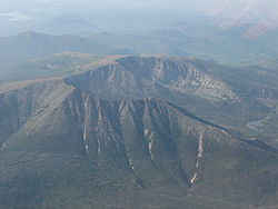 Katahdin is a huge mountain with several
summits. Baxter Peak, the 5,267 foot high point, is the northern terminus of the Appalachian Trail. A narrow ridge called the Knife Edge connects
Baxter Peak to South Baxter Peak, Chimney Peak, and Pamola Peak.
Katahdin is a huge mountain with several
summits. Baxter Peak, the 5,267 foot high point, is the northern terminus of the Appalachian Trail. A narrow ridge called the Knife Edge connects
Baxter Peak to South Baxter Peak, Chimney Peak, and Pamola Peak.
