


Wyoming State Almanac: Facts and Figures
Quick Facts, Figures, and Overview of the State of Wyoming
Wyoming is one of the Mountain states of the US. Wyoming is the 10th biggest state in the United States in terms of area. Wyoming is the 10th largest state in the US The capital of the state is Cheyenne and it is also the largest city. Wyoming is bordered on the north by Montana, on the east by South Dakota and Nebraska, on the south by Colorado, on the southwest by Utah, and on the west by Idaho. Delaware Indian word, meaning "mountains and valleys alternating"; the same as the Wyoming Valley in Pennsylvania. Legh Freeman, publisher of The Frontier Index in Kearny, Nebraska, claimed that it was he who first suggested Wyoming as the name for this portion of the Dakota Territory. Wyoming name comes from the Dakota "mscheweamiing" meaning "at the big flats" or "large plains."
Wyoming is the leading coal-producing state and a leader in the production of petroleum and natural gas. Wyoming has the world's largest sodium carbonate (natrona) deposits and has the nation's second largest uranium deposits.
A leading producer of sheep and wool, Wyoming is also a major producer of beef cattle and hogs. Principal crops include wheat, oats, sugar beets, corn, barley, and alfalfa.
Wyoming Almanac: Facts on the State of Wyoming |
|
|---|---|
| Official Name | Wyoming |
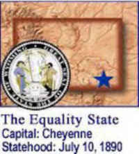
| Capital | Cheyenne |
| Nicknames | Equality State ...and more |
| Motto | Equal rights |
| Location Region |
41.14545 N, 104.79234 W Great Plains Northwestern Northwest, Pacific Rocky Mountains |
| Constitution Ratified | 1890 |
| Statehood | July 10, 1890 44th state |
| Population | 563,626 (2010) 5.09 sq. mi. 50th |
| Largest City (by population) |
10 largest cities (2010): Cheyenne, 59,011; Casper, 55,316; Laramie, 30,816; Gillette, 29,087; Rock Springs, 23,036; Sheridan, 17,444; Green River, 12,515; Evanston, 12,359; Riverton, 10,615; Cody, 9,520 |
| Bordering States | North: Montana East: South Dakota and Nebraska South: Colorado and Utah West: Utah, Idaho, and Montana |
| Major Industry | farming (cattle, sheep), mining (coal, uranium), oil, natural gas, tourism |
| Major Rivers | Bighorn River, Green River, Belle Fourche River, Powder River, North Platte River |
| Major Lakes | Yellowstone Lake, Glendo Reservoir, Bighorn Lake, Boysen Reservoir, Flaming Gorge Reservoir, Seminoe Reservoir, Alcova Reservoir, Keyhole Reservoir |
| Wyoming Counties | 23 Counties in Wyoming |
| Largest County (by population) |
Laramie County 91,738 (2010) 2,686 sq. mi. |
| Largest County (by area) |
Sweetwater County 10,426 sq. mi. |
| Electoral Votes | 3 |
| US Congress | 2 Senators; 1 Representative |
| Time Zone | Mountain Standard Time |
| Zip Codes | NANPA |
| State Quick Facts | Census Bureau Quick Facts |
Wyoming Climate and Weather |
|
|---|---|
| Wyoming is the second highest state in the United States,
and because of that elevation, conditions are normally on the dry side. Some areas of the state receive only 5 inches of rain, while in the mountains,
especially the Grand Tetons, 60 or more inches per year are common. Overall, throughout the state, mild springs are followed by warm (sometimes hot) summers, with cool morning lows. Fall brings occasional snow and cool temperatures, especially in the mountain canyons and higher elevations. Winter can be very cold with heavy snow in the mountains. The statewide average high temperature in July is just over 60 degrees, while in January, a 20 degree high is the average. |
|
| Highest Temperature | 114 degrees July 12, 1900 - Basin |
| Lowest Temperature | -63 degrees February 9, 1933 - Moran |
| Avg. Temp: High - Low |
87.1 degrees 11.9 degrees |
Wyoming Points of Interest |
|
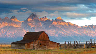
| Wyoming has many attractions for the tourist trade, notably Yellowstone National Park . Hikers, campers and skiers are attracted to Grand Teton National Park and Jackson Hole National Monument in the Teton Range of the Rockies. Cheyenne is famous for its annual "Frontier Days"celebration. Flaming Gorge, the Fort Laramie National Historic Site, and Devils Tower and Fossil Butte National Monuments are other points of interest and numerous ski resorts. | |
Wyoming Highest, Lowest, and Mean Elevations (Feet) |
|
| Mean Elevation: 6,700 feet | |
|
Highest Point: Gannett Peak: 13,804 feet
|
|
| Lowest Point: | Belle Fourche River 3,099 feet |
Wyoming Land Area (Square Miles) |
|
| Geographic Center | In Fremont County, 58 mi. ENE of Lander Longitude: 107°40.3'W Latitude: 42°58.3'N |
| Total Area | 97,813.56 sq. mi. 10th |
| Land Area | 97,100.40 sq. mi. 99.20% |
| Water Area | 713.16 sq. mi. 0.80% |
| Forested Land Area | 78.5% |
| Dimensions (Length - Width) |
360 miles - 280 miles |
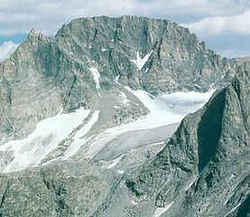 Gannett Peak is the highest peak
in the Wind River Range, and the highest peak in Wyoming. It rises on the Continental Divide, just southeast of Yellowstone National Park and the
Teton range. It is a snow peak in a range of rock peaks. It is flanked by five glaciers and its summit is snow-capped.
Gannett Peak is the highest peak
in the Wind River Range, and the highest peak in Wyoming. It rises on the Continental Divide, just southeast of Yellowstone National Park and the
Teton range. It is a snow peak in a range of rock peaks. It is flanked by five glaciers and its summit is snow-capped.
