

Click Image to Enlarge
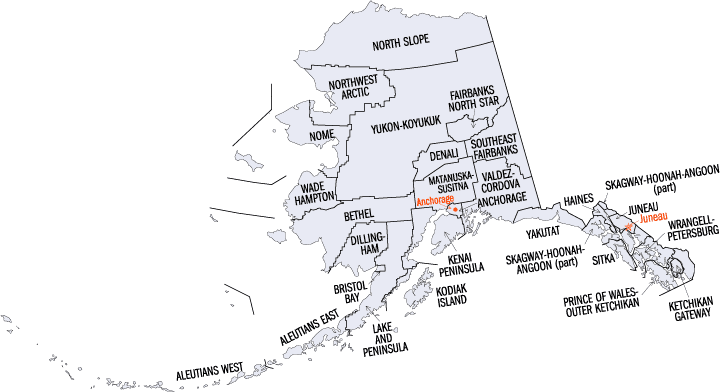
Alaska Boroughs
Alaska is divided into nineteen organized boroughs and one "Unorganized Borough." The Borough Act of 1961 created "The Unorganized Borough" including all of Alaska not within a Unified, Home rule, First class or Second class Borough. The newest borough is Petersburg incorporated after voters approved borough formation in December 2012. Alaska and Louisiana are the only states that do not call their first-order administrative subdivisions counties (Louisiana uses parishes instead)Bristol Bay Borough, Alaska
Bristol Bay Borough Education, Geography, and History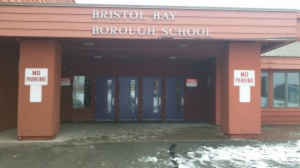
Bristol Bay Borough is a borough of the state of Alaska located on Bristol Bay or Lilgayaq Bay. Based on the 2010 census, the borough population was 997. There are no incorporated settlements. Incorporated in 1962, Bristol Bay was the first of Alaska's boroughs to be created. The borough seat of Bristol Bay Borough is Nakeneike. Bristol Bay Borough was named for Bristol Bay.
Etymology - Origin of Bristol Bay Borough Name
Bristol Bay Borough was incorporated in 1962, Bristol Bay was the first of Alaska's boroughs to be created.
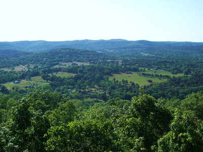
The borough is also among the smallest, consisting of little more than the rectangle of land around Naknek on the coast and King Salmon (which, uniquely, serves as the borough seat for neighboring Lake and Peninsula Borough) inland.
Demographics:
County QuickFacts: CensusBureau Quick Facts
History of Bristol Bay Borough, Alaska
The location of Bristol Bay is the most eastern arm of the Bering Sea, at 570 to 590 North 1570 to 1620 West. It is located between the southwest part of the Alaska mainland to its north, and the Alaska Peninsula to its south and east. Bristol Bay is 400 KM (250 miles) long and 290 KM, (180) miles wide at its mouth. Numerous rivers flow into the bay, including the Cinder, Igushik, Kvichak, Meshik, Nushagak, Naknek, Togiak, and Ugashik.
The Upper reaches of Bristol Bay experience some of the highest tides in the world. One such reach, the Nushagak Bay near Dillingham and another near Naknek in Kvichak Bay have tidal extremes in excess of 30 feet (9.9 meters), ranking them - and the area - as eighth highest in the whole world. This, coupled with the extreme number of shoals, sandbars and shallows waters, makes navigation to be troublesome, especially during the area's frequently strong winds.
As the shallowest part of the Bering Sea, Bristol Bay is understandably one of the most dangerous areas for any large vessels. This is one reason why the Bristol Bay commercial salmon fishing fleet is limited to 32-foot (10 meters) overall keel length. In addition, most of the area is not well documented by nautical charts and navigational aids are sparse.
The region was first settled by Athabascan Indians, Central Yup'ik Eskimos and Sugpiaq (Aleut-Russian) Eskimos. Hunting and fishing camps along the Naknek River date from 3,000 to 4,000 B.C. Around 1818, the first Russian traders arrived. Two years later, the first Russian settlement was established, and in 1841, the Russian Orthodox Mission was built at Nushagak. The Russians explored and maintained authority of the area until the US purchase of Alaska in 1867. US interests were directed primarily at the fur and fishery potential of the region. In 1883, the first salmon cannery in Bristol Bay was opened. Around 1890, the first cannery on the Naknek River was opened. Commercial salmon remain the region's major industry. During World War II, King Salmon Air Force Base was developed. The Bristol Bay Borough was incorporated as the state's first borough in 1962.
Much of Bristol Bay was dry and arable, along with much of the Bering Sea Land Bridge. More recently, its proximity to mineral, animal and seafood riches provided incentive for human habitation along its shoreline. Early Russian and English exploration provided most of the non-native influences of the area. During his voyage through the area in 1778, the famed British Navigator and explorer, Captain James Cook named the area "in honor of the Admiral Earl of Bristol" in England. After establishing some temporary settlements in the late 1790's, The Russian American Company sent exploratory parties to document the coast and nearby inland areas of Bristol Bay. One of these charted the area between the Kuskokwim and Nushagak Rivers. Later, in 1819, an Aleut by the name of Andrei Ustiugov drew the first intensive charts of Bristol Bay. Additionally, ships of the Russian Navy conducted extensive surveys of the Bering Sea coastline into the mid-1800's, naming many of the geographical features commonly used today: Capes Constantine, Chichagof, Menshikof and Greig, Mounts Veniaminof and Pavlof, Becharof Lake, etc.
Geography: Land and Water
The borough has a total area of 888 square miles (2,300 km2), of which 504 square miles (1,310 km2) is land and 384 square miles (990 km2) (43.2%) is water.
Bristol Bay is among the smallest, consisting of little more than the rectangle of land around Naknek on the coast and King Salmon (which, uniquely, serves as the borough seat for the neighboring Lake and Peninsula Borough) inland.
Neighboring Boroughs
Bordering boroughs are as follows:
- Southeast: Lake and Peninsula Borough
- Southwest: Bristol Bay
- Northwest: Dillingham census area
Education


Click Image to Enlarge
