

Click Image to Enlarge
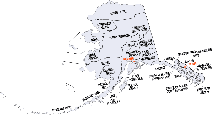
Alaska Boroughs
Alaska is divided into nineteen organized boroughs and one "Unorganized Borough." The Borough Act of 1961 created "The Unorganized Borough" including all of Alaska not within a Unified, Home rule, First class or Second class Borough. The newest borough is Petersburg incorporated after voters approved borough formation in December 2012. Alaska and Louisiana are the only states that do not call their first-order administrative subdivisions counties (Louisiana uses parishes instead)Kenai Peninsula Borough, Alaska
Kenai Peninsula Borough Education, Geography, and History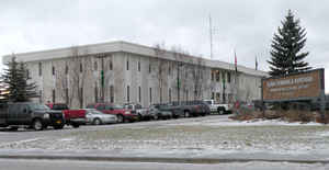
Kenai Peninsula Borough is a borough of the state of Alaska. Based on the 2010 census, the
population was 55,400. The borough
seat is
Soldotna. The borough was created in 1964. The Kenai
Peninsula Borough, whose named may be derived from
Kenayskaya, the Russian name for Cook Inlet.
The borough includes the Kenai Peninsula and adjacent areas of the mainland of Alaska.
Etymology - Origin of Kenai Peninsula Borough Name
The name Kenai is probably derived from Kenayskaya, the Russian name for the Cook Inlet. Kenai Peninsula Borough is comprised of the Kenai Peninsula, Cook Inlet and a large unpopulated area northeast of the Alaska Peninsula.
Demographics:
County QuickFacts: CensusBureau Quick Facts
History of Kenai Peninsula Borough, Alaska
The City of Kenai was founded around 1791 as a Russian fur trading post. In the early 1900's cannery operations and building of the railroad spurred development. It was the site of the first major Alaska oil strike, around 1957, and has been a center for exploration and production since that time. The Borough was formed in 1964.
The name Kenai is probably derived from Kenayskaya, the Russian name for the Cook Inlet. Kenai Peninsula Borough is comprised of the Kenai Peninsula, Cook Inlet and a large unpopulated area northeast of the Alaska Peninsula. The Borough includes portions of the Chugach National Forest, the Kenai National Wildlife Refuge, The Kenai Fjords National Park, and portions of the Lake Clark and Katmai National Park.
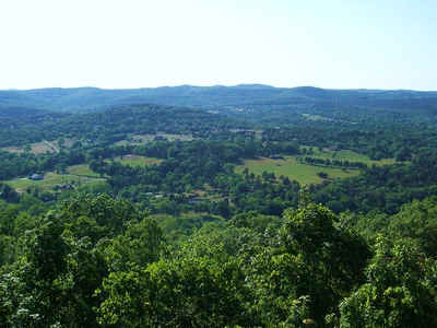
The glacier-covered Kenai Mountains (7,000 ft/2,130 m) and runs along the southeast spine of the peninsula along the coast of the Gulf of Alaska. Much of the range is within Kenai Fjords National Park. The northwest coast along the Cook Inlet is flatter and marshy, dotted with numerous small lakes. Several larger lakes extend through the interior of the peninsula, including Skilak Lake and Tustumena Lake. Rivers include the Kenai River, famous for its salmon population, as well as the Russian River, the Kasilof River, and Anchor River. Kachemak Bay, a small inlet off the larger Cook Inlet, extends into the peninsula's southwest end.
The peninsula includes several of the larger towns in southern Alaska, including Seward on the Gulf of Alaska Coast, Kenai along the Cook Inlet, and Homer, along Kachemak Bay in the south. Homer famously marks a terminus of the paved highway system of North America and is a popular destination for vehicle travelers who have driven to Alaska from the lower 48 states. Seward is the southern terminus of the Alaska Railroad.
The peninsula has a coastal climate that is mild, with abundant rainfall. It is one of the few areas in Alaska that allows for agriculture, with a growing season adequate for many crops. The peninsula also has natural gas, petroleum, coal deposits, and abundant commercial and personal use fisheries. Tourism is a major industry.
The twin Cities of Kenai and Soldotna are the population centers of the Borough, approximately 65 air miles south of Anchorage. It lies at approximately 60° 33' N Latitude, 151° 16' W Longitude . The community is located in the Kenai, Seward, Homer, Seldovia Recording District. The area encompasses 16,079 sq. miles of land and 5,585 sq. miles of water. The Kenaitze Indians (Dena'ina) have occupied the Peninsula historically
Geography
As reported by the Census Bureau, the borough has a total area of 24,752 square miles (64,110 km2), of which 16,075 square miles (41,630 km2) is land and 8,677 square miles (22,470 km2) (3.4%) is water.
Southcentral offers the advantages of remote wilderness, but is linked via roads. It is home to over half of Alaska's population with lakes and mountains. World-class rainbow trout and salmon shimmer in the rivers.
Neighboring Boroughs:
- Bethel Census Area, Alaska - northwest
- Matanuska-Susitna Borough, Alaska - north
- Municipality of Anchorage, Alaska - north
- Valdez-Cordova Census Area, Alaska - east
- Lake and Peninsula Borough, Alaska - west
Education


Click Image to Enlarge
