

Click Image to Enlarge
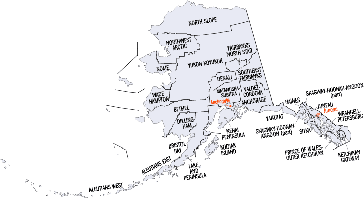
Alaska Boroughs
Alaska is divided into nineteen organized boroughs and one "Unorganized Borough." The Borough Act of 1961 created "The Unorganized Borough" including all of Alaska not within a Unified, Home rule, First class or Second class Borough. The newest borough is Petersburg incorporated after voters approved borough formation in December 2012. Alaska and Louisiana are the only states that do not call their first-order administrative subdivisions counties (Louisiana uses parishes instead)Matanuska-Susitna Borough, Alaska
Matanuska-Susitna Borough Education, Geography, and History
Matanuska-Susitna Borough (often referred to as the Mat-Su Borough) is a borough located in the state of Alaska. Based on the 2010 census, the
population was 88,995. Matanuska-Susitna Borough was
created in 1964. The borough seat is Palmer, and the largest city is Wasilla.
The borough was named
for the valley that the Matanuska and Susitna Rivers formed.
Matanuska-Susitna Borough is part of the Anchorage, AK Metropolitan Statistical Area.
The Mat-Su Borough is so designated because it contains the entire Matanuska and Susitna Rivers. These rivers empty into Cook Inlet which is
the southern border of the Mat-Su Borough. This area is one of the few agricultural areas of Alaska.
Etymology - Origin of Matanuska-Susitna Borough Name
The Mat-Su Borough is so designated because it contains the entire Matanuska and Susitna Rivers.
Demographics:
County QuickFacts: CensusBureau Quick Facts
History of Matanuska-Susitna Borough, Alaska
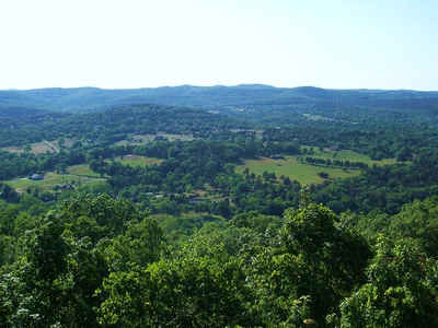
Abundant, fertile farmlands of the Matanuska and Susitna valleys make up this heart of Alaska borough. Homesteaders who led a farming lifestyle in the 1930s originally established in the area. Building of the statewide road system and the efficiency of the farmlands spurred population into development. Today, this Borough is one of the fastest increasing regions in Alaska. As reported by the Census Bureau, the area's population grew 49.5% from 1990 to 2000 - a growth rate three times the state run of the mill. Mat-Su Borough residents enjoy a rural lifestyle that is suitably close to municipal Anchorage. Many residents work in Anchorage, which is about a 40-mile travel. Tourism is on the rise, bringing visitors who fish and raft the area's remote rivers and lakes during the summer months. There are several lodges to support leisure activities. Just to the north of the Mat-Su Borough, Mount McKinley, North America's highest peak, attracts tourists and supports many local air taxi, helicopter, outfitter and climbing expedition businesses.
The local market of Wasilla is diverse, and residents are employed in a variety of city, borough, state, federal government, retail and professional service positions. Tourism, agriculture, wood products and the developed of steel and concrete products comprise the financial system. The George Parks Highway and the Glenn Highway connect Wasilla to Anchorage, as well as the remainder of the state and Canada. The Alaska Railroad serves Wasilla on the route from Seward to Fairbanks.
In 1935, Palmer became the site of one of the strangest experiments in American history: the Matanuska Valley Colony. The Federal Emergency Relief Administration, created by President Roosevelt, created a farming colony in Alaska. In 1935, about 200 families, mostly from Michigan, Wisconsin and Minnesota, joined the colony near Palmer. Although the farm failure rate was high, many descendants still live in the Mat-Su Valley. Palmer is located about 40 miles north of Anchorage on the Glenn Highway. Palmer's economy is based on a variety of retail and other services, as well as city, borough, state and federal government. Some light manufacturing occurs, but most residents are employed in Anchorage. Palmer is home to 200 musk ox, whose under wool is knitted into garments by Alaska Natives from 12 rural villages. Between 2,500 and 3,500 garments are created each year and sold by an Anchorage cooperative.
Lazy Mountain is a new a settlement on the Glenn Highway, located on the outskirts of Palmer. Most residents commute to the Palmer/Wasilla area for work or farming. Children are bused out for schooling. Grain, hay and potatoes are grown in the area.
Big Lake Residents are primarily employed in the Palmer and Wasilla area. There are several lodges on the lake to support summer entertaining boating and fishing activities. Unemployment is relatively low.
Geography: Land and Water
As reported by the Census Bureau, the borough has a total area of 25,258 square miles (65,420 km2), of which 24,608 square miles (63,730 km2) is land and 650 square miles (1,700 km2) (2.6%) is water.
Home to over half of Alaska's population with lakes and mountains. The South central area offers the advantages of remote wilderness, but is connected via roads. World-class rainbow trout and salmon glisten in the rivers.
Neighboring Boroughs
Bordering boroughs are as follows:
- Denali Borough, Alaska - north
- Southeast Fairbanks Census Area, Alaska - northeast
- Valdez-Cordova Census Area, Alaska - east
- Municipality of Anchorage, Alaska - south
- Kenai Peninsula Borough, Alaska - south
- Bethel Census Area, Alaska - west
Education


Click Image to Enlarge
