

Click Image to Enlarge
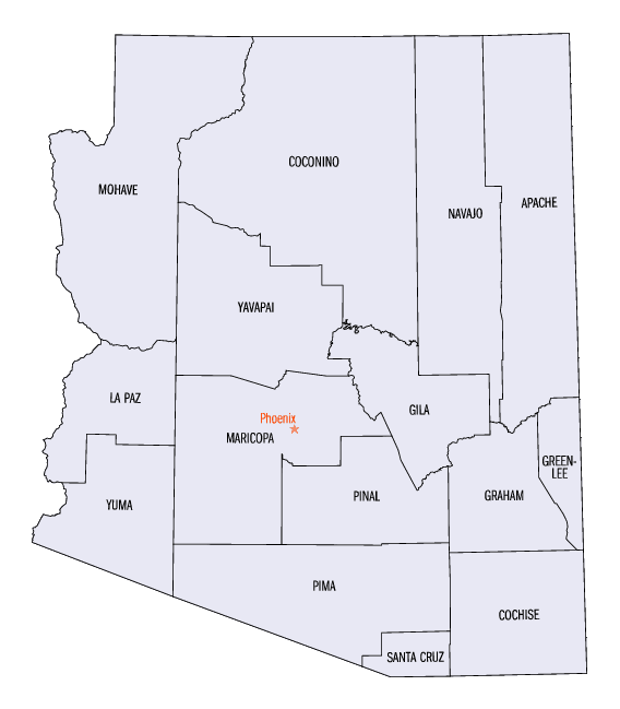
Arizona Counties
There are fifteen Counties in Arizona. There is one defunct county: Pah-Ute County formed in 1865 from Mohave County and returned in 1871. Four Counties (Mohave, Pima, Yavapai and Yuma) were created in 1864 following the organization of the Arizona Territory in 1862. The newest, La Paz County was created in 1983.Pima County, Arizona
Pima County Education, Geography, and History
Pima County is a county in the south central region of the state of Arizona. Based on the 2010 census, the
population was 980,263, making
it the second-most populous county in Arizona. Pima county was
created in 1864. The county seat is Tucson, where nearly all of the population is centered. The county is
named
after the Pima Native Americans who are indigenous to this area.
Pima County comprises the Tucson, AZ Metropolitan Statistical Area.
Etymology - Origin of Pima County Name
Pima county is named after the Pima Native American people, called in their own language Akimel O'odam (river people).
Demographics:
County QuickFacts: CensusBureau Quick Facts
Pima County History
Pima County, Arizona
Pima county is
bordered on the north by the Gila River; on the east by New Mexico; on the south by Sonora and on the west by Yuma County. It is the oldest occupied county in the Territory, and contains the most population. The western end of the county, to a line drawn north and south from the Gila river to the Sonora line, and passing a few miles west of Tucson, is uninhabited after leaving the Gila river, except by the Papago Indians, whose habitation will hereafter be described. This belt of country is composed of plains, covered with grass part of the year, and considerable portions of it with mesquite wood, and broken or detached chains of mountains. Wherever water can be found, grazing is excellent, and experience in sinking wells demonstrates that by this means water may be procured almost anywhere in Arizona-but without thus increasing the supply of water, much of this section must remain valueless. The south bank of the valley of the Gila extends the whole length of the
county, and, as before described, has superior agricultural advantages.
At Gila Bend, one hundred and fifty miles from the mouth of the river, the valley for a distance of twenty-five miles is from five to ten miles in width, and the soil is of the richest nature. A company is now engaged constructing a very large ditch for irrigating purposes, and offer shares for sale at the cost of building. Those who are not able to pay cash are furnished provisions and allowed to work for interests. There are many thousand acres of unoccupied land already surveyed, and subject to pre-eruption and entry at $1.25 per acre. There is a large volume of water remaining in the river, more than can be used through the ditch under construction. This section, in addition to being well adapted to raising vegetables and all the cereals, is undoubtedly, by soil and climate, favorable to growing oranges, lemons, figs and grapes.
Geography: Land and Water
As reported by the Census Bureau, the county has a total area of 9,189 square miles (23,800 km2), of which 9,187 square miles (23,790 km2) is land and 2.1 square miles (5.4 km2) (0.02%) is water.
The Tohono O'odham Nation, Buenos Aires National Wildlife
Refuge and Organ Pipe Cactus National Monument are located in Pima
county. This county's Santa Catalina Mountains, topped by 9,130-foot
Mount Lemmon, overlook Tucson, and the two sections of Saguaro National
Park bracket the city on the east and west.
Neighboring Counties
Bordering counties are as follows:
- North: Maricopa County; Pinal County
- Northeast: Graham County
- East: Cochise County
- Southeast: Santa Cruz County
- South: Sonora
- Northwest: Yuma County
Education


Click Image to Enlarge
