


Click Image to Enlarge
Arkansas Counties
The first of the Arkansas' seventy-five present-day counties created, Arkansas County was formed on 13 December 1813, when this area was part of the Missouri Territory.Ashley County, Arkansas
Ashley County Education, Geography, and History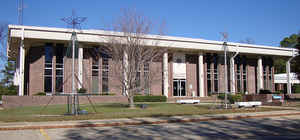
Ashley County is a county located in the state of Arkansas. Based on the 2010 census, the population was 21,853. The county seat is Hamburg. The county was formed in 1848 from parts of Chicot, Drew and Union Counties. Ashley county was named for Chester Ashley.
Etymology - Origin of Ashley County Name
Ashley is named for Chester Ashley, an US Senator and land speculator. Chester Ashley (June 1, 1791 - April 29, 1848) was an American politician who represented Arkansas in the US Senate from 1844 until his death.
Demographics:
County QuickFacts: CensusBureau Quick Facts
Ashley County History
The fifth largest county in the state was created on November 30, 1848, from part of Drew County with final boundary adjustments made in 1861. Hamburg is the county seat. The Ashley county courthouse is early contemporary in style and has a unique, round, courtroom where all participants in a trial face one another. The landscape of the county is coastal plain, level to rolling, flat cropland, and pine-forested hills. Two-thirds of Ashley County is hill land, most in pine timber and forest products with the first blocks of forestland being bought up by lumbermen in 1898. The original sawmill was in operation in 1901.
Another quarter of the county's land is devoted to agriculture. The rich sandy loam soil created by the Mississippi and Bayou Bartholomew rivers has been farmed for generations. Although cotton is still king, livestock, poultry and other commercial cash crops are grown. Bayou Bartholomew, the longest bayou in the United States runs through the county. West of the bayou is Overflow National Wildlife Refuge that offers excellent hunting and fishing. Ashley County has an innovative recycling program that has taken 65% of the waste stream out of their landfill. The county owns equipment to press paper and yard waste into small cubes, which are then sold to Georgia-Pacific for use as fuel. Today Georgia-Pacific owns 45% of the land in the county, supporting the manufacturing of hardwood veneer, plywood, paper and chemicals.
Ashley county is an alcohol prohibition or dry county.
Geography: Land and Water
As reported by the Census Bureau, the county has a total area of 941 square miles (2,440 km2), of which 925 square miles (2,400 km2) is land and 15 square miles (39 km2) (1.6%) is water. The lowest point in the state of Arkansas is located on the Ouachita River in Ashley County and Union County, where it flows out of Arkansas and into Louisiana.
The landscape of the county is coastal plain, level to rolling, flat cropland, and pine-forested hills. Two-thirds of Ashley County is hill land, most in pine timber and forest products with the first blocks of forestland being bought up by lumbermen in 1898. The original sawmill was in operation in 1901. Another quarter of the county's land is dedicated to agriculture. The rich sandy loam soil fashioned by the Mississippi and Bayou Bartholomew rivers has been farmed for generations. Although cotton is still king, livestock, poultry and other commercial cash crops are grown. Bayou Bartholomew, the longest bayou in the United States runs through the county. West of the bayou is Overflow National Wildlife Refuge that offers excellent hunting and fishing.
Neighboring Counties
Bordering counties are as follows:
- North: Drew County
- East: Chicot County
- South: Morehouse Parish, La.
- Southwest: Union Parish, La.
- West: Union County
- Northwest: Bradley County
Education


Click Image to Enlarge
