


Click Image to Enlarge
Arkansas Counties
The first of the Arkansas' seventy-five present-day counties created, Arkansas County was formed on 13 December 1813, when this area was part of the Missouri Territory.Clay County, Arkansas
Clay County Education, Geography, and History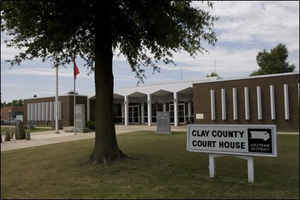
Clay County is a county located in the state of Arkansas. Based on the 2010 census, the population was 16,083. Clay County was formed on March 24, 1873, from parts of Randolph and Greene counties. The county has two county seats, Corning and Piggott. Clay county is named for Senator James M. Clayton.
Etymology - Origin of Clay County Name
Clay is named for John Clayton, a member of the state senate. When Clay County was created as Arkansas's 67th county on March 24, 1873 (along with Baxter County), it was named Clayton County, after John M. Clayton, then a member of the Arkansas Senate and a brother of then-US Senator Powell Clayton, though some sources suggest it may have been named for Powell Clayton instead.
Demographics:
County QuickFacts: CensusBureau Quick Facts
Clay County History
Clay county was created on March 24, 1873, from parts of Randolph and Greene counties. The county is named for Senator James M. Clayton. The county seat moved several times and officials finally settled on two county seats, as flooding on the Black and Cache Rivers often made passage impossible from one side of the county to the other. Clay County is unique in that it is surrounded on two sides by Missouri and two sides by Arkansas. It has two courthouses that are almost identical in appearance. The courthouse in Corning is in a residential area whereas the courthouse in Piggott is located in the center of town.
Two years later on December 6, 1875, the county's name was shortened to "Clay" by the Arkansas General Assembly. Some claim it was renamed for
the statesman Henry Clay, while others say John M. Clayton remained its official namesake. The name change apparently was inspired by
lingering distrust of Powell Clayton, as he had declared martial law and suspended elections in the county in 1868 when he was Governor of
Arkansas and it was still part of Greene County.
The first county seat was Corning, established in 1873, with the arrival of the St. Louis, Iron Mountain and Southern Railway, as the first
incorporated town in the county. The county seat was moved to Boydsville in 1877, because people living east of the Black and Cache Rivers had
difficulty getting to Corning during the flood season. However, this caused problems for those living west of the rivers, and in 1881 Corning
was re-established as the seat of the Western District, with Boydsville remaining the seat for the Eastern District. With the arrival of the
St. Louis, Arkansas and Texas Railroad in 1882, other towns such as Greenway, Rector and Piggott experienced growth. In 1887, the Eastern
District seat was moved to Piggott, and the dual county seat system remains in place today. Important county functions (such as the Quorum
Court) alternate between Piggott and Corning as their venues.
On April 6, 1972, Sheriff Douglas Batey and deputies Glen Ray Archer and Troy Key were shot and killed while trying to serve a warrant on Bert
Grissom. Grissom opened fire as soon as the men stepped out of their car. He later surrendered without resistance to another deputy, and was
tried, convicted, and sentence to life in prison. William Thomas Pond became sheriff, but he died in an automobile accident on June 8, 1973.
Four of the five police officers who have lost their lives serving the Clay County Sheriff's Office died in these two incidents.
The Black River divides the county. For many years, the only way to get from one of its courthouses to the other in the spring term of court, which normally occurred while the river was at flood stage, was to ride the railroad to Poplar Bluff, Missouri, spend the night, and catch the morning train to the other county seat, arriving late the second day. The major economy comes from general farming and raising livestock. Rice is the major crop, followed by cotton, soybeans, corn, hay, and milo. Light industry is scattered around.
Geography
As reported by the Census Bureau, the county has a total area of 641 square miles (1,660 km2), of which 639 square miles (1,660 km2) is land and 2.0 square miles (5.2 km2) (0.3%) is water.
Two rivers, the Cashe and the Black River offer many recreational sports such as duck hunting and fishing, horseback riding along the trails, hiking and picnicking.
Neighboring Counties
Bordering counties are as follows:
- North: Butler County, Mo.
- Southeast: Dunklin County, Mo.
- Southwest: Greene County
- West: Randolph County
- Northwest: Ripley County, Mo.
Education


Click Image to Enlarge
