


Click Image to Enlarge
Arkansas Counties
The first of the Arkansas' seventy-five present-day counties created, Arkansas County was formed on 13 December 1813, when this area was part of the Missouri Territory.Phillips County, Arkansas
Phillips County Education, Geography, and History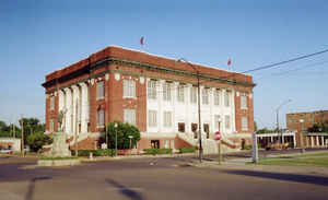
Phillips County is a county located in the state of Arkansas. Based on the 2010 census, the population was 21,757. The county seat is Helena-West Helena. Phillips County is Arkansas's seventh county, formed on May 1, 1820. Phillips county is named for Sylvanus Phillips, the area's first-known white settler and representative to the first Territorial Legislature of the Arkansas Territory.
The Helena-West Helena, AR Micropolitan Statistical Area includes all of Phillips County.
Etymology - Origin of Phillips County Name
Phillips county is named for Sylvanus Phillips, a member of the territorial legislature.
Demographics:
County QuickFacts: CensusBureau Quick Facts
Phillips County History
Phillips county was created on May 1, 1820, by the Territorial Legislature, and was named after Sylvanus Phillips, the area's first-known white settler and representative to the first Territorial Legislature. The county seat is Helena. Agriculture and agricultural chemicals have formed the basis of Phillips County's economy along with sporting and recreation on its many lakes and waterways. St. Francis National Forest, the smallest of the national forests, is
a semi-tropical haven for countless species of wildlife and vegetation. White River National Wildlife Refuge contains ox-bow lakes deposited by the White River and has some of the finest bass-fishing waters to be found. The refuge is home to some 227 species of non-game birds, 48 species of reptiles
and amphibians, and 30 species of mammals. Phillips is an old county with rich heritage. Nearly two dozen sites in the county are on the National Register of Historical Places. Phillips County Courthouse is a stately old building. At the northwest corner of the two-story building is a bronze statue
of a World War I doughboy with a fixed bayonet standing in the middle of the intersection of the adjoining redbrick paved streets. The Courthouse stands just inside the levee of the Mississippi River, and a U. S. Coast and Geodetic Survey benchmark located at the northwest corner of the building
shows that the elevation of the small courtyard in the fertile delta is 189.55 feet above sea level.
237 people were lynched there in 1919 during the Elaine race riot,
making Phillips County the site of the largest number of lynchings in US history.
Geography: Land and Water
As reported by the Census Bureau, the county has a total area of 727 square miles (1,880 km2), of which 696 square miles (1,800 km2) is land and 32 square miles (83 km2) (4.4%) is water.
The landscape of Phillips County is rich, flat, Delta farmland. The Mississippi River forms the eastern boundary.
Neighboring Counties
Bordering counties are as follows:
- North: Lee County
- Northeast: Tunica County, Miss.
- Southeast: Coahoma County, Miss.
- South: Bolivar County, Miss.
- Southwest: Desha County; Arkansas County
- Northwest: Monroe County
Education
School districts serving Phillips County include the Helena-West Helena School District, the Marvell Elaine School District, and the
Barton Lexa School District.
Previously the Lake View School District served a portion of the county. On July 1, 2004, the Lake View district merged into the Barton Lexa
district. Previously the Elaine School District served another portion of the county. On July 1, 2006, the Elaine district merged into the
Marvell district.
Marvell Academy, a private school founded in 1966 as a segregation academy is in unincorporated Phillips County, near Marvell.


Click Image to Enlarge
