


Click Image to Enlarge
Arkansas Counties
The first of the Arkansas' seventy-five present-day counties created, Arkansas County was formed on 13 December 1813, when this area was part of the Missouri Territory.St. Francis County, Arkansas
St. Francis County Education, Geography, and History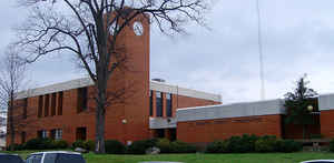
St. Francis County is a county located in the state of Arkansas. Based on the 2010 census, the
population was 28,258. The county
seat is
Forrest City. St. Francis county was created in October
1827, by the legislature of the Arkansas Territory, taking a part of
Phillips County. St. Francis is named for the St. Francis River.
St. Francis County comprises the Forrest City, AR Micropolitan Statistical Area, which is also included in the Memphis-Forrest City, TN-MS-AR
Combined Statistical Area.
Etymology - Origin of St. Francis County Name
St. Francis is named for the St. Francis River.
Demographics:
County QuickFacts: CensusBureau Quick Facts
St. Francis County History
St. Francis county was created in October 1827, by the legislature of the Arkansas Territory, taking a part of Phillips County, in which it was named after the St. Francis River that flows across it. The county seat is Forrest City. St. Francis County reliant on on rural agriculture now has light manufacturing to help its economy. Crowley's Ridge that runs through the county is noted for growing peaches and other fruit crops. The Arkansas Community College and the Crowley's Ridge Vo-Tech both are located in the county and are continuously working toward upgrading the skills of the work force. St. Francis County is at the crossroads of eastern Arkansas. Both railroads and major highways lead east to Memphis, west to Little Rock, and north to Jonesboro and south to Helena. Village Creek State Park has become the region's top recreational place with almost 7,000 acres on the St. Francis-Cross County line. Facilities include two fishing lakes, rental boats, trails, campsites, tennis courts, ball fields, swimming, and duck hunting. The courthouse is a 1972 contemporary structure and is located on the hill that was the site of Confederate General Nathan Bedford Forrest's camp while he was in charge of building the railroad from Little Rock to Memphis. The courthouse is known for its extensive use of large seals. The great seal of St. Francis County and the seal of the centennial of Forrest City, 1870-1970, both of which are three feet in diameter, are located in the foyer of the courtroom wing of the building. A three-foot brass seal of Arkansas dedicated to Judge R. B. McCullough, Sr., by his son, Judge Richard McCullough, is filed above the bench in the Chancery courtroom. A three-foot Great Seal of the County Court of St. Francis County hangs over the bench in the Circuit courtroom.
Geography: Land and Water
As reported by the Census Bureau, the county has a total area of 643 square miles (1,670 km2), of which 635 square miles (1,640 km2) is land and 7.7 square miles (20 km2) (1.2%) is water.
The landscape of the county is rich, flat farmland in the eastern and western halves and rolling hills in the center.
Neighboring Counties
Bordering counties are as follows:
- North: Cross County
- Northeast: Crittenden County
- South: Lee County
- Southwest: Monroe County
- Northwest: Woodruff County
Education


Click Image to Enlarge
