


Click Image to Enlarge
California Counties
The state of California is divided into fifty-eight counties. On January 4, 1850, the California constitutional committee recommended the formation of 18 counties. They were Benicia, Butte, Fremont, Los Angeles, Mariposa, Monterey, Mount Diablo, Oro, Redding, Sacramento, San Diego, San Francisco, San Joaquin, San Jose, San Luis Obispo, Santa Barbara, Sonoma, and Sutter. The last California county to have been established is Imperial County in 1907.Amador County, California
Amador County Education, Geography, and History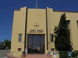
Amador County, officially the County of Amador, is a county located in the state of California, in the Sierra Nevada. Based on the 2010 census, the population was 38,091. The county
seat is Jackson. Amador County was created
in 1854 from parts of Calaveras and El Dorado Counties. The county is
named for Jose Maria Amador, soldier, rancher and
miner, who was born in San Francisco in 1794, the son of Sergeant Pedro
Amador, a Spanish soldier who settled in California in 1771.
Amador County bills itself as "The Heart of the Mother Lode" and lies within the Gold Country. There is a substantial viticultural industry in
the county.
Etymology - Origin of Amador County Name
The county is named for Jose Maria Amador, soldier, rancher and miner, who was born in San Francisco in 1794, the son of Sergeant Pedro Amador, a Spanish soldier who settled in California in 1771. In 1848, Jose Maria Amador, with several Indians, established a successful gold mining camp near the present town of Amador. In Spanish, the word amador means "lover of inanimate objects."
Demographics:
County QuickFacts: CensusBureau Quick Facts
Amador County History
Amador County county was created in 1854 from parts of Calaveras and El Dorado Counties. In 1864, part of the county's territory was given to Alpine County.
As early as 1843, John Sutter dispatched men to stands of cedar and sugar pine on the ridge
between today's Amador and Sutter Creeks. He called the place "Pine Woods." Sutter's men worked there sawing wood,
producing charcoal, and manufacturing other items needed at Sutter's Fort. Sutter's men still worked at Pine Woods,
even for a time after the gold discovery.
Before statehood, what is now Amador was part of the San Juaquin District and in 1849 had at least three precincts -
Drytown, Volcano, and Buena Vista Ranch - in the statewide elections of 1849. When California became a state in 1850,
Calaveras was one of the original 27 counties organized. But citizens northerly of the Mokelumne River were quickly
dissatisfied with being a stepchild province. After several years agitation, the county was finally divided in 1854 and
on June 14th, Amador was born.
Later it acquired land north of Dry Creek from El Dorado County and gave up its easterly Sierra territory when
Alpine County was formed in 1863. Jackson, which had been the county seat of Calaveras for a time in 1851-1852, edged
out Volcano to become county seat of the new county. Volcano threatened to wrest the honor away in 1857, but the effort
was stymied in the legislature at the eleventh hour. Jackson may be the only city which has been the county seat of two
counties.
Amador County is the only county in the state named after a native Californian - Jose Maria Amador, a wealthy ranchero
before the gold rush, whose great ranch covered much of what is now Amador Valley near Danville. He and his employees
mined along a creek in this county in 1848 and 1849. That creek became known as Amadore's Creek, and soon after, camps
called Amadore Crossing and South Amadore or Amadore City were founded.
Miners in the latter camp in 1852 first petitioned that a proposed new county be called "Amador" In 1854, when
legislation dividing Calaveras was debated, a motion to name the new county Amador instead of Washington was adopted.
Geography: Land and Water
As reported by the Census Bureau, the county has a total area of 605 square miles (1,566 km2), of which, 593 square miles (1,536 km2) of it is land and 12 square miles (30 km2) of it (1.94%) is water.
Amador County is located approximately 45 miles (72 km) southeast of Sacramento in a part of
California known as the foothills of the Sierra Nevada Mountains.
Neighboring Counties
Bordering counties are as follows:
- Northeast: El Dorado County
- East: Alpine County
- Southeast: Calaveras County
- Southwest: San Joaquin County
- West: Sacramento County
Education


Click Image to Enlarge
