


Click Image to Enlarge
California Counties
The state of California is divided into fifty-eight counties. On January 4, 1850, the California constitutional committee recommended the formation of 18 counties. They were Benicia, Butte, Fremont, Los Angeles, Mariposa, Monterey, Mount Diablo, Oro, Redding, Sacramento, San Diego, San Francisco, San Joaquin, San Jose, San Luis Obispo, Santa Barbara, Sonoma, and Sutter. The last California county to have been established is Imperial County in 1907.Mono County, California
Mono County Education, Geography, and History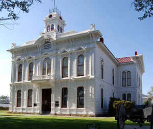
Mono County is a county located in the east central portion of the state of California. Based on the 2010 census, the population was 14,202. making it the fifth-least populous county in California. The county seat is Bridgeport. Mono county was created April 24, 1861. The county is named after Mono Lake. Mono Lake is named for an Indian tribe that inhabited the Sierra Nevada from north of Mono Lake to Owens Lake.
Etymology - Origin of Mono County Name
The county is named after Mono Lake, which, in 1852, was named for an Indian tribe that inhabited the Sierra Nevada from north of Mono Lake to Owens Lake. The tribe's western neighbors, the Yokuts, called them monachie, meaning "fly people," because the pupae of a fly was their chief food staple and trading article.
Demographics:
County QuickFacts: CensusBureau Quick Facts
Mono County History
The County of Mono was formed by an act of the Legislature on April 21, 1861 from parts of Calaveras County, Fresno County and Mariposa County. The county seat is in the town of Bridgeport, where most of the county offices are located in an historic courthouse built in 1880.
Parts of the county's territory were given to Inyo County in 1866.
Mono County was the first of the mining counties to be organized as such on the eastern slope of the Sierra Nevada mountains in the state of California. The county seat is in the town of Bridgeport. Most of the county offices are located in Bridgeport, in the handsome and historic courthouse which was built in 1880.
Located in the east-central section of California, Mono County averages 108 miles in length, reaching
from the Alpine County border to the north to the Inyo County border to the south. The average width of
the county is 38 miles from the crest of the mighty Sierras to the Nevada state line on the east.
Mono county land area is 3,030 square miles, 80% of which is Federally owned.
Much of this land is contained in the
Inyo and Toiyabe National Forests. The summer and fall visitors enjoy many
diverse activities such as
fishing, hunting, camping, hiking and some of the most spectacular scenery found in the Sierra Nevada
mountains. The county is a land rich in the history of the early days of the state and the west. Winter visitors
engage in snowmobiling, skiing, and various other winter sports at two of the
best winter sports and
skiing areas to be found in the entire country. These areas are located at Mammoth Mountain and June
Mountain.
Mono Lake, "The Dead Sea of Mono" appropriately called by poets and writers alike, "Mono's Mountains of the
Moon", is vibrantly described in the famous book "Roughing It" by Mark Twain. The lake is a
captivating
and rare body of water lying at the beginning of a chain of 21 extinct volcanic cones. The lake
burrows in a basin created by massive volcanic action. Wide thermal activity still exists in the
area surrounding the lake itself. In the center of this lake lie two islands, Negit and Paoha, that were
formed by ancient volcanic action. Mono Lake and the nearby area is famous for its water fowl
population and thousands of seagulls use the area for one of the largest rookeries in the west.
Mono county is able of accommodating a much larger population than it now has and in its strategic
position as the center of a huge scenic area along US Highway 395, between the
populated areas of
Southern California and the equally interesting and beautiful cities of Nevada. Mono County is
drawing an progressively large number of permanent residents who recognize its healthful and
enjoyable rewards.
Mono is known as the eastern gateway to Yosemite National Park.
Traveling over the famed Tioga Pass that leads from
the Mono Lake area to the floor of the well-known valley of Yosemite may be found some of the most
remarkable scenery in the western United States.
The ghost town of Bodie is located seven miles south and thirteen miles east of the town of Bridgeport,
the County seat. Bodie is now a State Historical Park, a National Historic Site and a California State
Historical Landmark. Bodie was known as the wildest, meanest and toughest of all the gold camps of
yesterday's west. The ghost of the "Bad Man From Bodie" still lives in legend along the eastern Sierra
Nevada Mountains. State Park Rangers are in constant attendance to assist visitors.
A beautiful highway crosses the southern portion of Mono County through the
scenic areas of old Benton and Chalfant Valley. This highway connects with U.S, Highway 395 at the
town of Bishop thereby affording an outstanding opportunity for persons travelling to California from the
east to visit Mono County by turning north on US Highway 395.
Geography: Land and Water
As reported by the Census Bureau, the county has a total area of 3,132 square miles (8,111.8 km2). 3,044 square miles (7,883.9 km2) of it is land and 87 square miles (225.3 km2) of it (2.79%) is water.
The land is rough, mountainous and outstanding. In general, Mono is a large plateau, 5,500 to
7,000 feet above sea level bordered on the west by the Sierra Nevada Mountains and on the east by the Bodie Hills and the White Mountains. The Sweetwater mountains lie along the northeastern border and the
rough White mountains are located on the extreme southeastern corner of the county. Lying between these
high mountain boundaries are steep canyons, broad valleys, many crystal clear lakes of glacial
formation and sage brush covered semi-desert land. The Sierra Nevada boundary is
dominated by three soaring peaks which rise to an elevation of over 13,000 feet; Mt, Dana, the
tallest, Mt, Lyell and Castle Peak. Land drainage in the county is
achieved by the East and West
Walker rivers to the north and by the Owens river to the south; and also by
countless Sierra streams.
Neighboring Counties
Bordering counties are as follows:
- North: Lyon County, Nev.
- Northeast: Mineral County, Nev.
- East: Esmeralda County, Nev.
- Southeast: Inyo County
- Southwest: Fresno County; Madera County
- West: Tuolumne County
- Northwest: Alpine County; Douglas County, Nev.
Education


Click Image to Enlarge
