


Click Image to Enlarge
California Counties
The state of California is divided into fifty-eight counties. On January 4, 1850, the California constitutional committee recommended the formation of 18 counties. They were Benicia, Butte, Fremont, Los Angeles, Mariposa, Monterey, Mount Diablo, Oro, Redding, Sacramento, San Diego, San Francisco, San Joaquin, San Jose, San Luis Obispo, Santa Barbara, Sonoma, and Sutter. The last California county to have been established is Imperial County in 1907.Placer County, California
Placer County Education, Geography, and History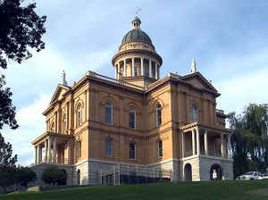
Placer County, officially the County of Placer, is a county located in the state of California. Based on the 2010 census, the
population
was 348,432. The county seat is Auburn.
Placer county was created April 25, 1851. The
Placer county name is probably a contraction of the
words plaza de oro (the place of gold) and in Spanish means "a place
near a river where gold is found."
Placer County is included in the Sacramento-Roseville-Arden-Arcade, CA Metropolitan Statistical Area. It is located in both the Sacramento
Valley and Sierra Nevada regions, in what is known as the Gold Country. It stretches from the suburbs of Sacramento to Lake Tahoe and the
Nevada border.
Etymology - Origin of Placer County Name
Placer is probably a contraction of the words plaza de oro (the place of gold) and in Spanish means "a place near a river where gold is found." The county derived its name from the numerous places where the method of extracting gold from the earth, called placer mining, was practiced.
Demographics:
County QuickFacts: CensusBureau Quick Facts
Placer County History
Placer County was created from parts of Sutter and Yuba Counties in 1851. The
county seat is
Auburn.
"Placer" Origin: 1835-45, Americanism; AmerSp; Sp: sandbank Catalan placel, deriv. of plaza open
place. Pronounced "plasser." The county derived its name from the numerous places where the placer mining
method of extracting gold was practiced.
Placer County was home to the peaceful Nisenan Native Americans for hundreds of years before the discovery of gold in
1848 brought hordes of miners from around the world.
Three years after the discovery of gold, Placer county was formed from portions of Sutter and Yuba
counties on April 25, 1851 with Auburn as the county seat. Placer County took its name from the Spanish word for sand or
gravel deposits containing gold. Miners washed away the gravel, leaving the heavier gold, in a process known as "placer
mining."
Gold mining was a main industry through the 1880s, but gradually the new residents turned to farming the fertile
foothill soil, harvesting timber and working for the Southern Pacific Railroad.
Auburn was established when Claude Chana discovered gold in Auburn Ravine in May 1848 and later became a shipping and supply
center for the nearby gold camps.
The cornerstone of Placer's historic courthouse, which is clearly visible from Interstate 80 through
Auburn, was laid on July 4, 1894. The building was renovated during the late 1980s and continues to serve the
public today with courtrooms, a historic sheriff's office and the Placer County Museum.
Roseville became a major railroad center and grew to the county's most populous city
after Southern Pacific Railroad moved its railroad switching yards there in 1908.
Loomis and Newcastle began as mining towns, but soon became centers of a booming fruit-growing industry, supporting many
local packing houses.
Penryn was founded by a Welsh miner, Griffith Griffith, who turned from mining to establish a large granite quarry.
Rocklin began as a railroad town and became home to a number of granite quarries. Rocklin now vies with
Roseville for the honor of being Placer's largest city.
Lincoln and Sheridan continue to support ranching and farming. Lincoln is the home of one of the county's oldest
businesses, the Gladding McBean terra cotta clay manufacturing plant established in 1875.
Foresthill was a active gold mining town for many years. Gradually the timber industry grew and was, until recently
the major employer. Recreation is now the major industry in this area of reservoirs,
unspoiled trails, and
abundant camping facilities.
Colfax began existence as railroad construction camp in 1865. Gold was discovered
in 1866. The Rising Sun, Montana
and Meda mines were rich gold producers.
Weimar was established as the timbering center of New England Mills. Weimar later became the home of the Weimar Institute, a
regional tuberculosis sanitarium. The Medical center closed when a cure for TB was discovered and is now a health and
nutrition center.
Geography: Land and Water
As reported by the Census Bureau, the county has a total area of 1503 square miles (3892 km2), of which, 1404 square miles (3637 km2) of it is land and 98 square miles (255 km2) of it (6.55%) is water. Watercourses in Placer County include the American River and Bunch Creek.
Within Placer county borders are scenic farm land and Gold-Rush era
towns speck the oak-covered foothills. Rocky peaks, forests, rivers and
clear alpine lakes create the natural beauty of the High Country.
Neighboring Counties
Bordering counties are as follows:
- North: Nevada County
- Northeast: Washoe County, Nev.
- Southeast: El Dorado County
- Southwest: Sacramento County
- West: Sutter County
- Northwest: Yuba County
Education


Click Image to Enlarge
