

Click Image to Enlarge
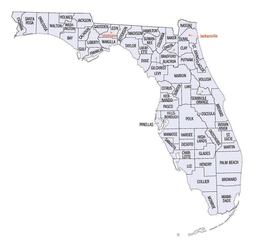
Florida Counties
There are sixty-seven counties in the state of Florida. In 1821, there were only two Counties in Florida: Escambia to the west and St. Johns to the east. From these two Counties were formed 67 today. Its last county was created in 1925 with the formation of Gilchrist County from a segment of Alachua County.Gadsden County, Florida
Gadsden County Education, Geography, and History
Gadsden County is a county located in the panhandle of the US state of Florida. Based on the 2010 census, the
population was 46,389. Gadsden County was
created on June 24, 1823 from Jackson County. The county
seat is Quincy. This county is named
for James Gadsden (1788-1858), American diplomat and namesake of the
Gadsden Purchase.
Gadsden County is included in the Tallahassee, FL Metropolitan Statistical Area.
Etymology - Origin of Gadsden County Name
Gadsden county is named for James Gadsden of South Carolina, aide-de-camp of Jackson in Florida campaign of 1818.
Demographics:
County QuickFacts: CensusBureau Quick Facts
Gadsden County History
Gadsden County was created in 1823. The county
is named for James Gadsden of South Carolina, who served as Andrew Jackson's
aide-de-camp in Florida in 1818.
When Florida became a territory in 1821, Andrew Jackson was appointed Governor and among his first duties, he subdivided
the state into two counties East Florida and West Florida. After several other divisions had taken place, on June 24,
1823, a fifth county generally spoken of as Middle Florida was established. Boundaries for the new county were the
Suwannee on the east and the Apalachicola River on the west and it was named Gadsden in honor of James Gadsden,
aide-de-camp to General Andrew Jackson in the Florida Campaign of 1818.
Pensacola was the scene for the first Legislative Council and Jacksonville, the site for the second. These two sessions,
two years and miles apart in hardship and distance, convinced the Council of the need for a central location. Two
commissioners, Dr. William Hayne Simmons and John Lee Williams were selected to explore a possible site in Middle
Florida. By March 4, 1824, these two commissioners reported they had chosen an area in Gadsden County, "about a mile
southwest from the deserted fields of Tallahassee Indians Village about a mile south of the Oke-lock-o-ny and
Tallahassee trails".
Gadsden County citizens played important roles in the capital city building project. The temporary capital was erected
in April 1824 by Jonathan Robinson and Sherod McCall. Their building was actually one of three log buildings constructed
to accommodate the Legislative Council which met November 8 of that year. The capital remained in Gadsden County until
December 29, 1824 when one of the first legislative acts that year was to create a new county (Leon) by annexing all the
lands of East Gadsden between the Ocklochonee and Suwannee Rivers which, without moving the structures, moved the
capital to Leon County.
Geography: Land and Water
As reported by the Census Bureau, the county has a total area of 528 square miles (1,369 km2), of which, 516
square miles (1,337 km2) of it is land and 12 square miles (32 km2) of it (2.34%) is water.
Gadsden County is located in the northwestern part of Florida. The county is approximately 32 miles long and 22 miles wide. The land area of 508 square miles is bounded on the east by the Ochlocknee River, on the west by the Apalachicola River, on the southeast by Lake Talquin and on the north by the State of Georgia. A humid temperature climate prevails, and rainfall is abundant and generally well distributed. The county is one of the foremost agricultural counties in northwest Florida.
Four major geological formations, all sedimentary, occur in Gadsden County at or near the surface of the ground.
From the oldest to youngest, these formations are Tampa limestone, the Hawthorn formation, Duplin marl, and the
Citronelle formation. Elevations range from about 50 feet above mean sea level to more than 300 feet above mean seal
level. Gadsden County has hills!
Neighboring Counties
Bordering counties are as follows:
- North: Decatur County, Ga.
- Northeast: Grady County, Ga.
- Southeast: Leon County
- Southwest: Liberty County; Calhoun County
- Northwest: Jackson County; Seminole County, Ga.
Education


Click Image to Enlarge
