


Click Image to Enlarge
Georgia Counties
Georgia is divided into one hundred and fifty-nine counties. The original eight counties of the State of Georgia were Burke, Camden, Chatham, Effingham, Glynn, Liberty, Richmond and Wilkes all created on February 5, 1777. The last new county to be established in Georgia was Peach County, established in 1924.Berrien County, Georgia
Berrien County Education, Geography, and History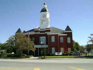
Berrien County is a county located in the state of Georgia. Based on the 2010 census, the population was 19,286. The county was created February 25, 1856 out of portions of Coffee, Irwin and Lowndes Counties by an act of the Georgia General Assembly. The county seat is Nashville. Berrien county is named after Georgia senator John M. Berrien.
Etymology - Origin of Berrien County Name
The county is named for John McPherson Berrien, a US Senator and Andrew Jackson's Attorney General.
Demographics:
County QuickFacts: CensusBureau Quick Facts
Berrien County History
Berrien County was created in 1856 from Coffee, Irwin, and Lowndes counties. The county was named for John McPherson Berrien, a US Senator and Andrew Jackson's Attorney General.
Berrien County had one of the state's earliest post roads, the Coffee Road. It was opened in 1823 to channel settlers' crops to Florida.
Nashville was named for General Francis Nash of North Carolina, a distinguished soldier of the Revolutionary War. Alapaha, named by Cherokee Indians who once lived there, means "smiling sunshine" or "laughing water".
Points of Interest
The county is predominantly agricultural and is known as the "Bell Pepper Capital of the World".
The old jail and the Berrien County Courthouse, both in Nashville, are listed on the National Register of Historic Places.
The Paradise Public Fishing Area is a 1,060-acre state-owned recreation/wildlife area. Fishing, picnicking, hiking, bird-watching, and primitive camping are available around its 76 lakes and ponds.
There are several animals on the Federal Endangered Species list found in Berrien County. These include the Peregrine Falcon, the Southern Bald Eagle, and the Florida Panther.
Geography: Land and Water
As reported by the Census Bureau, the county has a total area of 458 square miles (1,190 km2), of which 452 square miles (1,170 km2) is land and 6.0 square miles (16 km2) (1.3%) is water.
Berrien county is located in south Georgia. The western portion of Berrien County, from just north of US Route 82 and roughly west of US Route 129 heading south, is located in the Withlacoochee River sub-basin of the Suwannee River basin. The eastern portion of the county is located in the Alapaha River sub-basin of the larger Suwannee River basin.
Neighboring Counties
Bordering counties are as follows:
- North: Irwin County
- Northeast: Coffee County
- East: Atkinson County
- Southeast: Lanier County
- South: Lowndes County
- Southwest: Cook County
- Northwest: Tift County
Education


Click Image to Enlarge
