


Click Image to Enlarge
Georgia Counties
Georgia is divided into one hundred and fifty-nine counties. The original eight counties of the State of Georgia were Burke, Camden, Chatham, Effingham, Glynn, Liberty, Richmond and Wilkes all created on February 5, 1777. The last new county to be established in Georgia was Peach County, established in 1924.Butts County, Georgia
Butts County Education, Geography, and History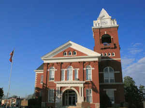
Butts County is a county located in the northern half of the state of Georgia. Based on the 2010 census, the
population was 23,655. The county was created on December 24, 1825.
The county seat is Jackson. The county
is named in honor of Captain Samuel Butts (1777 -
1814), a hero of the Creek War.
Butts County is included in the Atlanta-Sandy Springs-Roswell, GA Metropolitan Statistical Area.
Etymology - Origin of Butts County Name
The county is named for Captain Samuel Butts, a militiaman killed fighting Creek Indians in the War of 1812.
Demographics:
County QuickFacts: CensusBureau Quick Facts
ButtsCounty History
The 64th county formed in Georgia, was created from Henry and Monroe counties. It was named for Captain Samuel Butts, a militiaman killed fighting Creek Indians in the War of 1812.
Historic sites abound in Butts County, like Indian Springs Hotel (1823), the Indian Springs Church (1855), the Butts County Courthouse (1898), the Old Flovilla School (1885-1932), and historic private homes.
Jackson, the county seat, was named for President Andrew Jackson.
Points of Interest
Lake Jackson, one of the earliest reservoirs in Georgia, was formed in 1910 when the Central Georgia Power Company completed a dam and hydroelectric plant at Lloyd Shoals on the Ocmulgee River.
Indian Springs is the oldest state park in the United States. The Creek Indians used the springs for centuries to heal their sick and to keep the healthy well. It was also the site of the treaty that ceded the Creek Indian lands to the state of Georgia in 1825.
Notable Citizens
Robert Grier was one of Butts County's notable citizens. He was the publisher of Grier's Almanac which has been published annually since 1807. Current sales average 2.5 million copies a year.
Geography: Land and Water
As reported by the Census Bureau, the county has a total area of 188 square miles (490 km2), of which 184 square miles (480 km2) is land and 3.6 square miles (9.3 km2) (1.9%) is water.
Butts county is located close to the center of Georgia. The county is in the Ocmulgee River basin.
Neighboring Counties
Bordering counties are as follows:
- Northeast: Newton County
- East: Jasper County
- South: Monroe County
- Southwest: Lamar County
- West: Spalding County
- Northwest: Henry County
Education


Click Image to Enlarge
