


Click Image to Enlarge
Georgia Counties
Georgia is divided into one hundred and fifty-nine counties. The original eight counties of the State of Georgia were Burke, Camden, Chatham, Effingham, Glynn, Liberty, Richmond and Wilkes all created on February 5, 1777. The last new county to be established in Georgia was Peach County, established in 1924.Decatur County, Georgia
Decatur County Education, Geography, and History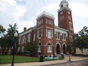
Decatur County is a county located in the state of Georgia. Based on the 2010 census, the
population was 27,842. Decatur County was
created on December 8, 1823 from Early County. The county
seat is
Bainbridge. The county is named in honor of Commodore
Stephen Decatur (1779-1820), a naval hero of the actions against the
Barbary Pirates in the early 1800s.
Decatur County comprises the Bainbridge, GA Micropolitan Statistical Area, which is included in the Tallahassee-Bainbridge, FL-GA Combined
Statistical Area.
Etymology - Origin of Decatur County Name
The county is named in honor of Commodore Stephen Decatur who defeated the Barbary Coast pirates at Tripoli in 1815.
Demographics:
County QuickFacts: CensusBureau Quick Facts
Decatur County History
Decatur County was created in 1823 from portions of Early County. The county was named in honor of Commodore Stephen Decatur who defeated the Barbary Coast pirates at Tripoli in 1815. Bainbridge, the county seat, was named for Commodore William Bainbridge,
commander of the US Constitution, "Old Ironsides."
The Decatur County area was the site of several battles between Indians and early settlers. In the early 1700s, both the Spanish and English fought with Creek Indians. In 1818, General Andrew Jackson led troops from Tennessee, Kentucky, and Georgia to victory over the Seminole Indians.
Points of Interest
Decatur County is divided by the Flint River, which flows to meet the Chattahoochee. Together they form the Apalachicola River which flows to the Gulf of Mexico. At the junction of the two rivers, the Jim Woodruff Dam forms Lake Seminole. A system of locks at the dam allows barge traffic to
travel between the inland port at Bainbridge and the Gulf of Mexico.
The limestone aquifer underlying Decatur County is broken in many places, encouraging the formation of caves and lime sinks-one at Curry's Mill is almost 700 feet wide and reaches a depth of 102 feet.
Decatur County is the nation's leader in the production of Fuller's Earth, a type of clay with varied chemical uses. Once used for bleaching petroleum and cleaning grease out of wool, Fuller's Earth is currently used as cat litter and as an additive to insecticides and cements.
Lake Seminole is widely regarded as one of the nation's best lakes for large mouth bass fishing. In addition, local anglers fish for striped and white bass, catfish, crappy, and bream. Also, Lake Seminole is popular among area duck hunters.
Geography: Land and Water
As reported by the Census Bureau, the county has a total area of 623 square miles (1,610 km2), of which 597 square miles (1,550 km2) is land and 26 square miles (67 km2) (4.2%) is water.
Decatur county is located in southwest Georgia. The county is in the Flint River basin and the Ochlockonee River basin.
Neighboring Counties
Bordering counties are as follows:
- North: Baker County
- Northeast: Mitchell County
- East: Grady County
- South: Gadsden County, Fla.
- West: Jackson County, Fla.; Seminole County
- Northwest: Miller County
Education
Higher Education
Bainbridge College


Click Image to Enlarge
