


Click Image to Enlarge
Georgia Counties
Georgia is divided into one hundred and fifty-nine counties. The original eight counties of the State of Georgia were Burke, Camden, Chatham, Effingham, Glynn, Liberty, Richmond and Wilkes all created on February 5, 1777. The last new county to be established in Georgia was Peach County, established in 1924.Dodge County, Georgia
Dodge County Education, Geography, and History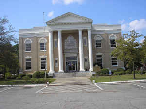
Dodge County is a county located in the state of Georgia. As of 2010, the population was 21,796. Dodge County was created on October 26, 1870 from Montgomery, Pulaski, and Telfair counties. The county seat is Eastman. The county is named in honor of William Earle Dodge (1805 - 1883), a temperance leader and businessman from [New York, and a cofounder of Phelps, Dodge, and Company, a mining and metals company.
Etymology - Origin of Dodge County Name
The county is named for William E. Dodge, a New York businessman who owned large tracts of forest land in Georgia. Dodge helped persuade Congress to remove taxation from timber and built the first county courthouse in 1908 as a gift.
Demographics:
County QuickFacts: CensusBureau Quick Facts
Dodge County History
Dodge County was created in 1870 from parts of Montgomery, Pulaski, and Telfair counties. Georgia's 134th county was named for William E. Dodge, a New York businessman who owned large tracts of forest land in Georgia. Dodge helped persuade Congress to
remove taxation from timber and built the first county courthouse in 1908 as a gift. The current courthouse was recently renovated by the county.
Eastman, the largest city and the county seat, was named for W. P. Eastman, a friend of Dodge.
Points of Interest
Eastman is the home of the original Stuckey Candy Plant and is referred to as the "Candy Capital of Georgia." The Eastman House includes a museum of history for Dodge county and Eastman. The home was built in 1872 by William P. Eastman.
Geography: Land and Water
As reported by the Census Bureau, the county has a total area of 503 square miles (1,300 km2), of which 496 square miles (1,280 km2) is land and 7.2 square miles (19 km2) (1.4%) is water.
Dodge county is located close to the center of Georgia. The county is in the Ocmulgee River basin and the Oconee River basin. Dodge County lies in the Historic South region of Georgia, an area that has architectural wonders and shows the cultural aspects of the South.
Neighboring Counties
Bordering counties are as follows:
- Northeast: Laurens County
- East: Wheeler County
- Southeast: Telfair County
- Southwest: Wilcox County
- West: Pulaski County
- Northwest: Bleckley County
Education


Click Image to Enlarge
