


Click Image to Enlarge
Georgia Counties
Georgia is divided into one hundred and fifty-nine counties. The original eight counties of the State of Georgia were Burke, Camden, Chatham, Effingham, Glynn, Liberty, Richmond and Wilkes all created on February 5, 1777. The last new county to be established in Georgia was Peach County, established in 1924.Pickens County, Georgia
Pickens County Education, Geography, and History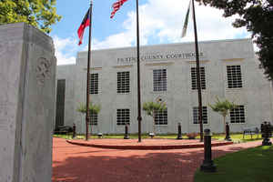
Pickens County is a county located in the state of Georgia. Based on the 2010 census, the
population was 29,431. Pickens County was
created on December 5, 1853. The county
seat is
Jasper. The county is named in honor of General Andrew
Pickens (1739-1817), a hero of the Revolutionary War and U.S.
Congressman.
Pickens County is part of the Atlanta-Sandy Springs-Roswell, GA Metropolitan Statistical Area.
Etymology - Origin of Pickens County Name
The county is named for General Andrew Pickens, a Revolutionary War soldier.
Demographics:
County QuickFacts: CensusBureau Quick Facts
Pickens County History
Pickens County was created in 1853 from parts of Cherokee and Gilmer counties. Georgia's 100th county was named for General Andrew Pickens, a Revolutionary War soldier.
A railroad line built in 1883 from Atlanta, through the valleys and mountain passes of Pickens County to Tate and Nelson, made possible the development of large marble quarries. One of the largest marble veins in the world is in Pickens County, running at least four miles long. It is a half-mile
deep and almost that wide in places. Over 60 percent of the monuments in Washington, D.C. are made from Pickens County marble.
The Old Federal Road, the earliest vehicular route through northwest Georgia, crossed northern Pickens County at Talking Rock Creek.
Geography: Land and Water
As reported by the Census Bureau, the county has a total area of 233 square miles (600 km2), of which 232 square miles (600 km2) is land and 0.7 square miles (1.8 km2) (0.3%) is water.
Pickens county is located in north Georgia. The highest point in Pickens County is the 3,288 foot summit of Mount Oglethorpe, the
southernmost peak in the Blue Ridge Mountains and, for a number of years, the southern terminus of the Appalachian Trail.
Other notable peaks in Pickens County include Sharp Top Mountain and Sharp Mountain. One of the best viewpoints of Sharp Top Mountain is from
Grandview Lake Dam on Grandview Road.
Pickens is in the Coosa River basin.
Neighboring Counties
Bordering counties are as follows:
- North: Gilmer County
- East: Dawson County
- South: Cherokee County
- Southwest: Bartow County
- West: Gordon County
Education
Higher Education
Appalachian Technical College


Click Image to Enlarge
