


Click Image to Enlarge
Georgia Counties
Georgia is divided into one hundred and fifty-nine counties. The original eight counties of the State of Georgia were Burke, Camden, Chatham, Effingham, Glynn, Liberty, Richmond and Wilkes all created on February 5, 1777. The last new county to be established in Georgia was Peach County, established in 1924.Pierce County, Georgia
Pierce County Education, Geography, and History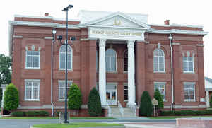
Pierce County is a county located in the state of Georgia. Based on the 2010 census, the
population was 18,758. Pierce County was
created on December 18, 1857. The county
seat is
Blackshear. The county is named in honor of Franklin
Pierce (1804-1869), fourteenth President of the United States.
Pierce County is part of the Waycross, GA Micropolitan Statistical Area.
Etymology - Origin of Pierce County Name
The county is named for Franklin Pierce, 14th President of the United States.
Demographics:
County QuickFacts: CensusBureau Quick Facts
Pierce County History
Pierce County was created from parts of Appling and Ware counties. Georgia's 119th county was named for Franklin Pierce, 14th President of the United States.
Blackshear was named for General David Blackshear, who supervised construction of the Blackshear Road. Patterson was named for William Patterson who resettled in the county from New York. He ran a sawmill in the area.
The Pierce County courthouse is listed on the National Register of Historic Places. There have been preliminary efforts to have the old Blackshear Jail and its hanging tower listed on the National Register.
A Confederate prison camp in Pierce County held about 5,000 Union prisoners of war during the last months of the Civil War. Prisoners were transferred to Pierce County from Millen, and possibly Andersonville, so that Sherman's troops would not be able to free them on their march south.
Points of Interest
The Marion Anderson Library Black Heritage Collection in Blackshear contains about 300 volumes and oil paintings addressing African-American heritage. This is the largest publicly accessible collection of this type in the region.
Pierce County shares the Little Satilla Wildlife Management Area with Wayne County to the east.
Geography: Land and Water
As reported by the Census Bureau, the county has a total area of 343 square miles (890 km2), of which 316 square miles (820 km2) is land and 27 square miles (70 km2) (7.8%) is water.
Pierce county is located in southeast Georgia. The county is in the Satilla River basin.
Neighboring Counties
Bordering counties are as follows:
- North: Appling County
- Northeast: Wayne County
- Southeast: Brantley County
- Southwest: Ware County
- Northwest: Bacon County
Education


Click Image to Enlarge
