


Click Image to Enlarge
Idaho Counties
There are forty-four Counties in Idaho. When Idaho became a territory in March, 1863, there were four Counties in existence: Boise, Idaho, Nez Perce and Shoshone. By the time Idaho became a state, there were 15 counties. The rest of the 44 Counties came into existence during the 30 years after Idaho became a state. Two of the former counties disappeared during this time. Alturas, which was created in 1864, was later divided into the many counties now found in central Idaho. Logan County was only in existence for six years, from 1889 to 1895. It was combined with Alturas to form Blaine County and Lincoln County, which was formed just two weeks after Logan lost its identity.Nez Perce County, Idaho
Nez Perce County Education, Geography, and History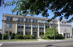
Nez Perce County is a county located in the state of Idaho. Based on the 2010 census, the
population was 39,265. The State of Idaho was
created as territory on March 3, 1863. The county
seat is
Lewiston. The county is named for the Nez Perce tribe.
Nez Perce County is part of the Lewiston, ID-WA Metropolitan Statistical Area.
Etymology - Origin of Nez Perce County Name
Nez Perce County is named for the Nez Perce Native American tribe.
Demographics:
County QuickFacts: CensusBureau Quick Facts
Nez Perce County History
Established February 4, 1864 by the Idaho Territorial Legislature with its county seat at Lewiston. Named for the Nez Perce Indians who occupied the area before the white man. Previously established by the Territorial Legislature of Washington in 1861. This was one of the four original Idaho counties in 1863 from which all 44 have been carved. The present boundaries of Nez Perce County were set in 1911. Lewis and Clark were the first white men in the area in 1805. Lewiston served as the territorial capital for twenty-two months before the capital was moved to Boise.
Geography
As reported by the Census Bureau, the county has a total area of 856 square miles (2,220 km2), of which 848 square miles (2,200 km2) is
land and 8.2 square miles (21 km2) (1.0%) is water.
Nez Perce county is located in northwest Idaho.
Nez Perce County has two rivers, the Clearwater and the Snake, which meet in Lewiston and then flow west. The Clearwater flows from the east
and the Snake from the south, creating the state border with Washington (and further upstream, Oregon). The lowest point in the state of Idaho
is located on the Snake River in Lewiston in Nez Perce County, where it flows out of Idaho and into Washington. North of Lewiston, Idaho's
western border is a political line.
The northern portion of the county is part of the Palouse, a wide and rolling agricultural region of the middle Columbia basin.
Neighboring Counties
Bordering counties are as follows:
- North: Latah County
- Northeast: Clearwater County
- Southeast: Lewis County; Idaho County
- Southwest: Wallowa County, Ore.; Asotin County, Wash.
- Northwest: Whitman County, Wash.
Education


Click Image to Enlarge
