


Click Image to Enlarge
Idaho Counties
There are forty-four Counties in Idaho. When Idaho became a territory in March, 1863, there were four Counties in existence: Boise, Idaho, Nez Perce and Shoshone. By the time Idaho became a state, there were 15 counties. The rest of the 44 Counties came into existence during the 30 years after Idaho became a state. Two of the former counties disappeared during this time. Alturas, which was created in 1864, was later divided into the many counties now found in central Idaho. Logan County was only in existence for six years, from 1889 to 1895. It was combined with Alturas to form Blaine County and Lincoln County, which was formed just two weeks after Logan lost its identity.Twin Falls County, Idaho
Twin Falls County Education, Geography, and History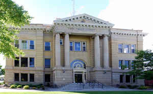
Twin Falls County is a county in the south central part of the state of Idaho. Based on the 2010 census, the county had a
population of
77,230. Twin Falls County was created on February 21,
1907. The county seat and largest city is Twin Falls.
The county is named for the Twin Falls waterfall on the
Snake River.
Twin Falls County is part of the Twin Falls, ID Micropolitan Statistical Area.
Etymology - Origin of Twin Falls County Name
Twin Falls County is named for a waterfall on the Snake River.
Demographics:
County QuickFacts: CensusBureau Quick Facts
Twin Falls County History
Established February 21, 1907 with its county seat at Twin Falls. Named for the nearby waterfalls on the Snake River. A station line was established at Rock Creek in 1864 for the Ben Holladay Stage Line. The Twin Falls South Side project brought water to thousands of acres of arid land in 1904 and became one of the most successful in the Carey Act irrigation projects.
Geography: Land and Water
As reported by the Census Bureau, the county has a total area of 1,928 square miles (4,990 km2), of which 1,921 square miles (4,980 km2) is land and 7.1 square miles (18 km2) (0.4%) is water.
Twin Falls county is located in south Idaho. Hagerman Fossil Beds National Monument and part of Sawtooth National Forest is located in this county.
Neighboring Counties
Bordering counties are as follows:
- North: Gooding County
- Northeast: Jerome County
- East: Cassia County
- Southwest: Elko County, Nev.
- West: Owyhee County
- Northwest: Elmore County
Education


Click Image to Enlarge
