


Click Image to Enlarge
Illinois Counties
There are one hundred and two counties in Illinois. St. Clair County was the first county established in what is today Illinois. Most counties in Illinois were named after early American leaders, especially of the American Revolutionary War, as well as soldiers from the Battle of Tippecanoe and the War of 1812.Coles County, Illinois
Coles County Education, Geography, and History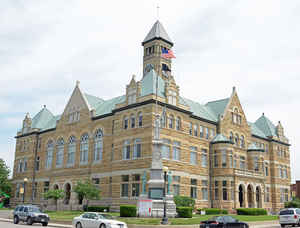
Coles County is a county located in the state of Illinois. Based on the 2010 census, the
population was 53,873. Coles County was created
on December 25, 1830. The county seat is
Charleston, which is also the home of Eastern Illinois University. The
county is named after Edward Coles, second Governor of Illinois.
Coles County is part of the Charleston-Mattoon, IL Micropolitan Statistical Area.
Etymology - Origin of Coles County Name
The county is named after Edward Coles, second Governor of Illinois.
Demographics:
County QuickFacts: CensusBureau Quick Facts
Coles County History
Pioneer Migration
Coles County was created on December 25, 1830 (Laws, 1831, p. 59) and was formed from Clark and Edgar Counties.
Present area, or parts of it, formerly included in: Edgar County (1823-1830), Clark County (1819-1823), Crawford
County (1815-1819), Madison County (1812-1815), St. Clair County (1801-1812) and Knox, Northwest Territory
(1790-1801).
The County was named for Edward Coles, the second Governor of the State of Illinois. Coles served as Governor from
December 5, 1822 to December 6, 1826. The County Seat is Charleston (1831-Present).
Between 1820 and 1840, two migrations settled Illinois. One, from New York and New England, settled Northern
Illinois. A second stream from Ohio and Wabash River valleys, settled in Southern Illinois, including Coles County.
Prior to 1820, there were no permanent settlements in the County. This was partly because the treaty with the
Indians relinquishing their title to the area was not made until 1818 and because as late as 1820, there still
battles between Indians and government surveyors in the Wabash River valley. After the Indian threat had been
squelched, settlements began to fill up the interior of Illinois with a series of short (30 - 60 miles) migration.
Many pioneers migrated through Coles County, because it was on one of the routes West from Indiana and Kentucky. One
major route was the Vincennes Trace, which passed from Vincennes, Indiana to Kaskaskia in Southwestern Illinois.
Normally this route would have passed about 50 miles South of Charleston, however, frequent flooding of the Wabash
and Embarras rivers in this region necessitated passing North through Coles County. Many settlers crossed the
Embarras River South of Charleston.
A second factor determining settlement of Coles County was its topography. In contrast to areas to its North and
West, Coles County was located on the timberline. Two major rivers drained the County: the Embarras on the East side
of the County and the smaller Kaskaskia (Au Kas or Okaw) on the West side. Along the rivers and their tributaries
were forests. Groves were scattered throughout the County. Surrounding the wooded areas, primarily in the Northern
and Western parts of the County, was a broad, flat prairie known as the "Grand Prairie." This land was wet and
swampy and was not drained for cultivation until the last half of the century.
Early settlers in Coles County preferred to start homesteads in the timberlands. Timber provided a source of
building materials and fuel. The wooded land was actually more tillable at the time, because of much of the prairie
was under water. Many settlers preferred the timberland for no other reason than it looked like home. The vast
majority of early settlers came from points South and East - wooded areas of Indiana, Kentucky and Tennessee.
Whatever the reason, the timberland was settled first, primarily by Southern stock coming to the County by way of
the Ohio and Wabash River valleys. The prairie was settled much later primarily by persons of Eastern stock. This
difference was reflected in many aspects of the early Coles County culture, including social life, politics and
house types.
Early Settlements
The first permanent settlement in Coles County occurred in 1824 in Hutton Township near the Embarras River. In
that year, a small group of men from Crawford County crossed the river at that point and decided to settle there.
One of the early settlers, Benjamin Parker, built his cabin on the East bank of the river about where the Water
Plant Dam is now. In 1826, Parker moved to the present site of Charleston and was joined by other settlers, thus
forming a permanent settlement. After these first settlements were formed, the County grew quickly.
By 1830, the area had grown so much that requests were made to the state legislature for establishment of county
government offices in the area to better serve the new residents. Consequently, Coles County was established on
Christmas Day, 1830, and was named for Edward Coles, Governor of Illinois in 1822. Charleston was designated the
County Seat one year later, giving impetus for growth of the new settlement by Parker and its namesake Charles
Morton.
Early Coles County was much larger in area than it is today. The original county boundaries included Cumberland and
Douglas counties. These were detached in 1843 and 1859 respectively, Douglas County being the last Illinois county
to be formed. Settlement patterns in Coles County changed drastically from that of the first settlement on the
Embarras River. By 1834, J.M. Peck's Gazetteer of Illinois listed 11 settlements in the County, most of them still
in wooded areas or along the river.
By 1840, Coles County had a population of 9,615 persons and rapid growth associated with initial settlement had
subsided. By 1870, the population had grown to 25,235, the increase due primarily to the establishment of
North-South and East-West railroad through the County in 1855.
The coming of the railroad resulted in a major shift to settlement patterns as new communities developed along the
railroad lines. The largest railroad settlement, now the city of Mattoon, was established where the two lines
crossed. After 1870, growth was steady but slow. County population in 1880, 1890 and 1900 was 27,042, 30,093 and
34,136 respectively.
Geography: Land and Water
As reported by the Census Bureau, the county has a total area of 510 square miles (1,321 km2), of which 508 square miles (1,316 km2) is land and 2 square miles (5 km2) (0.35%) is water.
Coles county is located close to the center of Illinois. Fox Ridge
State Park is located in this county.
Neighboring Counties
Bordering counties are as follows:
- North: Douglas County
- Northeast: Edgar County
- Southeast: Clark County
- South: Cumberland County
- Southwest: Shelby County
- Northwest: Moultrie County
Education


Click Image to Enlarge
