


Click Image to Enlarge
Illinois Counties
There are one hundred and two counties in Illinois. St. Clair County was the first county established in what is today Illinois. Most counties in Illinois were named after early American leaders, especially of the American Revolutionary War, as well as soldiers from the Battle of Tippecanoe and the War of 1812.Ford County, Illinois
Ford County Education, Geography, and History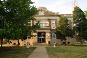
Ford County is a county located in the state of Illinois. According to the 2010 census, it had a
population of 14,081. Ford County was created
on February 17, 1859. The county seat
is Paxton. The county is named for Thomas Ford
(1800-1850), eighth Governor of Illinois and he served during the
Illinois Mormon War.
Ford County is part of the Champaign-Urbana, IL Metropolitan Statistical Area.
Etymology - Origin of Ford County Name
The County was named for Thomas Ford, the eighth Governor of the State of Illinois. Ford served Governor of the State of Illinois from December 8, 1842 to December 9, 1846.
Demographics:
County QuickFacts: CensusBureau Quick Facts
Ford County History
Ford County was created on February 17, 1859 (Laws, 1859, p. 29) and was formed from unorganized (Vermilion County).
Present area, or parts of it, formerly included in: Vermilion County (1826-1859), Edgar County (1823-1826), Clark County
(1819-1823), Crawford County (1816-1819), Edwards County (1815-1816), Madison County (1812-1815), St. Clair County
(1801-1812) and Knox, Northwest Territory (1790-1801).
The County was named for Thomas Ford, the eighth Governor of the State of Illinois. Ford served Governor of the State of
Illinois from December 8, 1842 to December 9, 1846. The County Seat is Paxton (Name changed from Prospect City in
September, 1859).
History of Ford 1859 to
1959
1859 - FORD COUNTY - 1959
(this information from Centurama Celebrating The First 100 Years of Ford County, Illinois 1859-1959)
Geography: Land and Water
As reported by the Census Bureau, the county has a total area of 486 square miles (1,260 km2), of which, 486 square miles (1,258 km2) of it is land and 1 square miles (1 km2) of it (0.11%) is water.
Ford county is located close to the center of Illinois.
Neighboring Counties
Bordering counties are as follows:
- Northeast: Kankakee County; Iroquois County
- Southeast: Vermilion County
- South: Champaign County
- West: McLean County
- Northwest: Livingston County
Education


Click Image to Enlarge
