


Click Image to Enlarge
Illinois Counties
There are one hundred and two counties in Illinois. St. Clair County was the first county established in what is today Illinois. Most counties in Illinois were named after early American leaders, especially of the American Revolutionary War, as well as soldiers from the Battle of Tippecanoe and the War of 1812.Jefferson County, Illinois
Jefferson County Education, Geography, and History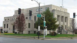
Jefferson County is a county located in the southern part of the state of Illinois. According to the 2010 census, it has a population of 38,827. Jefferson County was created on March 26, 1819. The county seat is Mount Vernon. The county is named for Thomas Jefferson (1743-1826), third President of the United States.
Jefferson County comprises the Mount Vernon, IL Micropolitan Statistical Area. It is located in the southern portion known locally as "Little
Egypt".
The western border of the county adjoins the Greater St. Louis consolidated metropolitan statistical area, the Metro-East region, and the St.
Louis commuter region and market and viewing area.
Etymology - Origin of Jefferson County Name
The county is named for Thomas Jefferson (1743-1826), third President of the United States, second Vice President of the United States, Governor of Virginia, and one of the foremost Founding Fathers of the United States.
Demographics:
County QuickFacts: CensusBureau Quick Facts
Jefferson County History
Jefferson County was created on March 26, 1819 (Laws, 1819, p. 51) and was formed from Edwards and White Counties. Present area, or parts of it, formerly included in: Edwards County 1815-1819), White County (1815-1819), Gallatin County (1812-1815), Randolph County (1795-1813), St. Clair County (1790-1803) and Knox, Northwest Territory (1790-1801).
The County was named for Thomas Jefferson, third President of the United States (1801-1809) and author of the Declaration of Independence. The County Seat is Mt. Vernon (1819-Present).
Source: History of Jefferson County, Illinois
By: John A. Wall © 1909
Jefferson county, so called in honor of Thomas Jefferson, the third President of the United States, and the reputed writer and signer of the Declaration of Independence. As designated by Legislative act, it is situated southeast of the intersection of the old Ohio & Mississippi (now Baltimore & Ohio Southwestern) Railroad, and is bounded on the north by Marion county, on the east by Wayne and Hamilton counties, on the south by Franklin county, on the west by Washington and Perry counties, and has an area of five hundred seventy-six square miles. When it was "first attacked" by the settlers, about four-fifths of the territory was timber land, and one fifth prairie, the latter being in elevated levels between the watercourses.
The first settlements of Jefferson County were made under great difficulties, and amid hardships and dangers. Most of the settlers were from the states south of the Ohio river, and were poor in wordly wealth called by some "poor white trash." But while they had but little education, and comparitively no wealth, they were men and women of sterling worth physically stalwart and strenuous, looking upon labor as an honor, and a glory, which nothing could be accomplished without.
Source: History of Jefferson County, Illinois
Compiled by: Continental Historical Bureau 1962
exerts from pages 1 through 3
The county of Jefferson was organized in 1819, a few months after Illinois became a state. The new county which bore the name of the author of the Declaration of Independence was to contain sixteen townships.
The next major step after establishing the boundaries of the county was to decide on the county seat of justice was to be. The decision that was to be made was to be permanent. The founding fathers decided that the capital of the newly organized county was to be where the city of Mt. Vernon, Illinois is now located.
It will be interesting to know that Jefferson County was organized much sooner than many of the other counties in
Illinois. Marion County, which borders Jefferson County on the north, was not organized until 1823, five years after
Congress had admitted the new state.
Mount Vernon has had two names, founders of the newly established hamlet were desirous of giving their new town a
name that in their opinion would sound beautiful, and they first named it Mount Pleasant. The center of the hamlet
was located on the summit of a slope, and it is believed that this is where they concieved the idea of using the
word Mount. The slope mentioned is the location of the Jefferson County Court House.
The name George Washington has always been popular with the American people, and he is the idol of many. Following the war for Independence, the "Father of His Country" and his home at Mt. Vernon, Virginia, were already held in high esteem by the people of the country. Not too long after the hamlet had been given it;s original name, the early inhabitants of the community decided that they wanted their town to be named after the home of their hero. This idea met popular approval of the settlers of the community. As a result of the strong demand for the name to be changed, it was given the official name of Mount Vernon.
The admission of Illinois to the union occured December 3, 1818, the County of Jefferson was organized March 26,
1819, a period of 113 days later. The official beginning of Mt. Vernon took place June 7, 1819, seventy-three days
after the organization; it was only 186 days after the state had officially been admitted to the Union until Mt.
Vernon was officially born.
Geography: Land and Water
As reported by the Census Bureau, the county has a total area of 584 square miles (1,512 km2), of which, 571 square miles (1,479 km2) of it is land and 13 square miles (33 km2) of it (2.19%) is water.
Jefferson county is located in south Illinois. Part of Ten Mile Creek State Fish & Wildlife Area is located in this county.
Neighboring Counties
Bordering counties are as follows:
- North: Marion County
- Northeast: Wayne County
- Southeast: Hamilton County
- South: Franklin County
- Southwest: Perry County
- West: Washington County
Education


Click Image to Enlarge
