


Click Image to Enlarge
Indiana Counties
Indiana is divided into ninety-two counties. The oldest and newest Counties in Indiana are Knox County (created 1790) and Newton County (created 1857).Many Indiana counties are named for the US Founding Fathers and personalities of the American Revolutionary War, the War of 1812 and Battle of Tippecanoe; early leaders of Indiana Territory and Indiana, as well as surrounding states like Michigan and Kentucky; plus Native American tribes and geographical features.Huntington County, Indiana
Huntington County Education, Geography, and History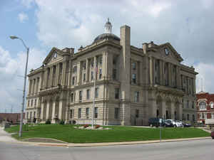
Huntington County is a county located in the state of Indiana. According to Census 2010, the
population was 37,124. Huntington County was
created on December 2, 1834. The county
seat
and lone city is Huntington. The county is named for
Samuel Huntington, signer the Declaration of Independence.
Huntington County comprises the Huntington, IN Micropolitan Statistical Area and is included in the Fort Wayne-Huntington-Auburn Combined
Statistical Area
Etymology - Origin of Huntington County Name
The county is named for Samuel Huntington, signer of the Declaration of Independence.
Demographics:
County QuickFacts: CensusBureau Quick Facts
HuntingtonCounty History
Huntington County was organized effective December 2, 1834 and Captain Elias Murray, then a member of the Legislature, proposed the name. Huntington is the County Seat.
Huntington County is divided into 12 Civil Townships as follows: Clear Creek, Dallas, Huntington, Jackson, Jefferson, Lancaster, Polk, Rock Creek, Salamonie, Union, Warren and Wayne.
Geography: Land and Water
As reported by the Census Bureau, the county has a total area of 388 square miles (1,005 km2), of which 383 square miles (991 km2) is land and 5 square miles (14 km2) (1.38%) is water.
Huntington county is located in northeast Indiana. Salamonie Lake, Matter Park, and Paradise Spring Park are located in this county.
Neighboring Counties
Bordering counties are as follows:
- North: Whitley County
- Northeast: Allen County
- Southeast: Wells County
- Southwest: Grant County
- West: Wabash County
Education


Click Image to Enlarge
