


Click Image to Enlarge
Indiana Counties
Indiana is divided into ninety-two counties. The oldest and newest Counties in Indiana are Knox County (created 1790) and Newton County (created 1857).Many Indiana counties are named for the US Founding Fathers and personalities of the American Revolutionary War, the War of 1812 and Battle of Tippecanoe; early leaders of Indiana Territory and Indiana, as well as surrounding states like Michigan and Kentucky; plus Native American tribes and geographical features.LaGrange County, Indiana
LaGrange County Education, Geography, and History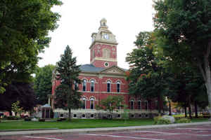
LaGrange County is a county located in the state of Indiana. As of 2010, the
population was 37,128. LaGrange County was
created on April 1, 1832. The county seat is LaGrange,
Indiana. The county is named for the ancestral estate
of the Marquis de la Fayette, the French-born hero of the American
Revolutionary War.
Etymology - Origin of LaGrange County Name
The county is named for the Revolutionary War hero Marquis de Lafayette's home in Paris.
Demographics:
County QuickFacts: CensusBureau Quick Facts
LaGrange County History
LaGrange County was formally organized April 1, 1832.
LaGrange County is divided in to 11 Civil Townships as follows: Bloomfield, Clay, Clearspring, Eden, Greenfield, Johnson, Lima, Milford, Newbury, Springfield and Van Buren.
The first settlement of LaGrange County was founded about a half mile west of Lima in 1828. Over the next four years,
settlers flocked to parts of Lima, Springfield, and Van Buren Townships. Finally in 1832, LaGrange County was carved out
of neighboring Elkhart County and established with Lima as the county seat. The town of LaGrange was platted in 1836 and
settled in 1842 as the new county seat, closer to the center of the county. Lima's name was changed to Howe in 1909.
In 1837, the government removed Chief Shipshewana and the Potawatomi Tribe from the northwest corner of the county.
Several years later the Chief was allowed to return and died in Newbury Township in 1841. A town named Georgetown had
been platted in 1837 but was abandoned due to lack of development. In 1844, the first Amish came from Pennsylvania to
settle around the old town. The village continued not to grow and the town of Shipshewana was platted nearby in 1899 and
incorporated in 1916 in Newbury Township.
LaGrange County was named after the home of Revolutionary War hero, the Marquis de la Fayette, outside of Paris, France.
Geography: Land and Water
As reported by the Census Bureau, the county has a total area of 387 square miles (1,002 km2), of which 380
square miles (983 km2) is land and 7 square miles (19 km2) (1.85%) is water.
LaGrange county is located in north Indiana. The county is mostly made up of rural farm land but also some rolling hills and several lakes.
Neighboring Counties
Bordering counties are as follows:
- Northeast: Branch County, Mich.
- East: Steuben County
- Southeast: DeKalb County
- South: Noble County
- West: Elkhart County
- Northwest: St. Joseph County, Mich.
Education
The county has three public school districts and the Howe Military School.


Click Image to Enlarge
