


Click Image to Enlarge
Indiana Counties
Indiana is divided into ninety-two counties. The oldest and newest Counties in Indiana are Knox County (created 1790) and Newton County (created 1857).Many Indiana counties are named for the US Founding Fathers and personalities of the American Revolutionary War, the War of 1812 and Battle of Tippecanoe; early leaders of Indiana Territory and Indiana, as well as surrounding states like Michigan and Kentucky; plus Native American tribes and geographical features.Noble County, Indiana
Noble County Education, Geography, and History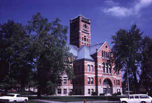
Noble County is a county located in the state of Indiana. As of 2010, the
population was 47,536. Noble County was created
on March 1, 1836. The county seat is
Albion. The county is named for United States Senator
James Noble who was then Governor of Indiana and was also Indianas'
first United
States Senator.
Noble County comprises the Kendallville, IN Micropolitan Statistical Area and is included in the Fort Wayne-Huntington-Auburn, IN Combined Statistical Area.
Etymology - Origin of Noble County Name
The county is named for James Noble who was then the Governor of Indiana and was also Indiana's first United States Senator.
Demographics:
County QuickFacts: CensusBureau Quick Facts
Noble County History
Noble County was first included in Randolph County, next in Allen County, then in Lagrange County and finally, on March 1, 1836 was organized as it stands today except for a strip two miles wide that was joined to Whitley County It was named for Governor Noah Noble
Noble County is divided into 13 Civil Townships as follows: Albion, Allen, Elkhart, Green, Jefferson, Noble, Orange, Perry, Sparta, Swan, Washington, Wayne and York.
Geography: Land and Water
As reported by the Census Bureau, the county has a total area of 418 square miles (1,082 km2), of which 411 square miles (1,065 km2) is land and 6 square miles (17 km2) (1.56%) is water.
Noble county is located in north Indiana. Sand Hill (1076 feet/328 metres), the second-highest point in Indiana, is located in this county.
Neighboring Counties
Bordering counties are as follows:
- North: Lagrange County
- Northeast: Steuben County
- East: DeKalb County
- Southeast: Allen County
- Southwest: Whitley County; Kosciusko County
- Northwest: Elkhart County
Education


Click Image to Enlarge
