


Click Image to Enlarge
Indiana Counties
Indiana is divided into ninety-two counties. The oldest and newest Counties in Indiana are Knox County (created 1790) and Newton County (created 1857).Many Indiana counties are named for the US Founding Fathers and personalities of the American Revolutionary War, the War of 1812 and Battle of Tippecanoe; early leaders of Indiana Territory and Indiana, as well as surrounding states like Michigan and Kentucky; plus Native American tribes and geographical features.Sullivan County, Indiana
Sullivan County Education, Geography, and History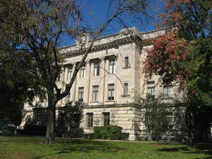
Sullivan County is a county located in the state of Indiana. As of 2010, the
population was 21,475. Sullivan County was
created on January 15, 1817. The county
seat is Sullivan. The county is named
for General Daniel Sullivan, American Revolutionary War hero.
Sullivan County is included in the Terre Haute, Indiana, metropolitan statistical area.
Etymology - Origin of Sullivan County Name
The county is named for Revolutionary War hero General Daniel Sullivan who was killed by the Indians on the road from Vincennes to Louisville while carrying an express in the public service.
Demographics:
County QuickFacts: CensusBureau Quick Facts
Sullivan County History
Sullivan County was organized by an act of Legislature, which became effective January 15, 1817.
Sullivan County is divided into 9 Civil Townships as follows: Cass, Curry, Fairbanks, Gill, Haddon, Hamilton, Jackson, Jefferson and Turman.
On 25 February 1779 Col. George Rogers Clark captured Fort Sackville at Vincennes from the British. About six miles
(10 km) west at Pointe Coupee on the Wabash River on 2 March 1779, Capt. Leonard Helm commanding three boats and 50
volunteers from Vincennes captured a reinforcement fleet of seven boats carrying 40 soldiers and valuable supplies and
Indian trade goods. This small naval battle completed the destruction of British military strength in the Wabash Valley.
The county's first settlement occurred between 1808 and 1812, by a religious society of celibates known as Shakers. The
400 members of this communal group occupied 1,300 acres (5 km2), seven miles (11 km) west of Carlisle.
General William Henry Harrison's army made its last camp in Sullivan County at Big Springs on September 29, 1811.
Harrison used Benjamin Truman's fort as his headquarters. With spring water available, it was an ideal location for 1000
men, including 160 dragoons and 60 mounted riflemen. A Kentucky soldier killed a fellow Kentuckian, Clark, either
accidentally or in a grudge fight. The deceased was buried at the top of a hill that became the Mann Truman Cemetery.
General Harrison and his troops continued north on the Wea Indiana Trail to build Fort Harrison and then proceeded to
the Battle of Tippecanoe.
A War of 1812 military action occurred in September, 1812, three miles (5 km) west/southwest of Sullivan County. While
escorting supplies from Fort Knox near Vincennes to Fort Harrison at Terre Haute, Sergeant Nathan Fairbanks and
approximately a dozen soldiers were ambushed - and most killed - by Indians.
In 1815, Carlisle was founded.
Sullivan County was formed in 1817. It was named for Daniel Sullivan, said by some sources to have been a Revolutionary
War general killed by Native Americans while carrying a dispatch between Fort Vincennes and Louisville.
A log courthouse in Merom served as Sullivan County's first county seat from 1819-1842. Merom was an important river
port and a stop on the stage route known as The Old Harrison Trail. William Henry Harrison's troops camped near here on
their 1811 march to the Battle of Tippecanoe.
Pioneer heroine of abdominal surgery Jane Todd is buried in Sullivan County. Born in Virginia in 1763, she and her
husband, Thomas Crawford, moved to Green County, Kentucky, in 1805. Suffering from a huge abdominal tumor, she rode 60
miles (100 km) to Danville, Kentucky, to submit to an operation never before performed. On December 25, 1809, Dr.
Ephraim McDowell performed this, the first ovariotomy, in his home. The ordeal lasted 25 minutes. There was no
anesthesia. Mrs. Crawford recovered completely and years later came to Graysville to live with her son, Thomas, a
Presbyterian minister. She died in 1842 at age 78. The restored McDowell home in Danville, Kentucky is a surgical
shrine.
Sullivan was founded in 1853 and became the county seat.
Dedicated in 1862, Union Christian College served as a preparatory school and college until 1924. In 1936 it became
Merom Institute- a rural enrichment center. Now owned by the United Church of Christ, it serves as a camp, conference,
and retreat center.
Numerous violent conflicts erupted in Sullivan County during the American Civil War over differing war sentiments. On
July 14, 1864, anti-war Democrat John Drake was fatally shot at a community picnic near here.
Organized nationally to bring culture to rural communities, Merom's 10-day religious and educational Chautauqua event
featured concerts, debates, plays, and lectures. Carrie Nation, William Jennings Bryan, William Howard Taft, Warren G.
Harding, and Billy Sunday were among the speakers here.
In 1905, the Sullivan Daily Times was founded by Paul Poynter, patriarch of the most famous newspaper families in the
country. Eleanor Poynter Jamison operated it, while her brother, Nelson Poynter, went on to operate the St. Petersburg
Times. Today it is still family owned and operated, one of only 200 daily papers of its kind.
In 1968 Sullivan County Park and Lake was founded. It contains a 468-acre (1.9 km2) reservoir in 1968 for swimming,
boating and fishing. The lake is stocked with crappie and hybrid saugeye, as well as bass, bluegill and channel catfish.
Water skiing is also very popular. Sullivan County Park and Lake has 400 acres (1.6 km2) of land for camping as well as
a 9-hole golf course. The campground offers sites ranging from primitive camping to space for modern motor homes.
There is a movement in the county and among its neighbors to switch to the Central Time Zone in the future.
Geography: Land and Water
As reported by the Census Bureau, the county has a total area of 454 square miles (1,176 km2), of which 447 square miles (1,158 km2) is land and 7 square miles (18 km2) (1.51%) is water.
Sullivan county is located in southwest Indiana. Lake Sullivan is located in this county and was created in 1968 for the purpose of flood control and conservation.
Neighboring Counties
Bordering counties are as follows:
- North: Vigo County
- Northeast: Clay County
- East: Greene County
- South: Knox County
- Southwest: Crawford County, Ill.
- Northwest: Clark County, Ill.
Education


Click Image to Enlarge
