


Click Image to Enlarge
Indiana Counties
Indiana is divided into ninety-two counties. The oldest and newest Counties in Indiana are Knox County (created 1790) and Newton County (created 1857).Many Indiana counties are named for the US Founding Fathers and personalities of the American Revolutionary War, the War of 1812 and Battle of Tippecanoe; early leaders of Indiana Territory and Indiana, as well as surrounding states like Michigan and Kentucky; plus Native American tribes and geographical features.Vigo County, Indiana
Vigo County Education, Geography, and History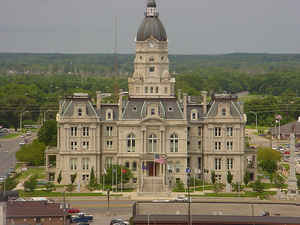
Vigo County is a county located along the western border of the state of Indiana. According to the 2010 census, the
population was
107,848. Vigo County was created on March 21, 1818. The
county seat is Terre Haute. The county
is named for Francis Vigo, Italian-born colonial spy
during the American Revolutionary War.
Vigo County is included in the Terre Haute, Indiana, Metropolitan Statistical Area.
Etymology - Origin of Vigo County Name
The county is named for Revolutionary War hero Colonel Francis Vigo, a native of Sardinia, Italy, who came to Vincennes about 1777 and died in that city March 1836.
Demographics:
County QuickFacts: CensusBureau Quick Facts
Vigo County History
Vigo County, pronounced (Ve-go), was organized by an act of the Legislature March 21, 1818 becoming effective February 15, 1818. The county is named in honor of Col. Francis Vigo, of Italian heritage but a citizen of Spain due to residence in St. Louis. He is credited with great assistance to George Rogers Clark both in financing Clark's exploration and Revolutionary War efforts, and in service as an agent obtaining military information for Clark against British campaigns on the then frontier.
Vigo County is divided into 12 Civil Townships as follows: Fayette, Harrison, Honey Creek, Linton, Lost Creek, Nevins, Otter Creek, Pierson, Prairie Creek, Prairieton, Riley and Sugar Creek.
Geography: Land and Water
As reported by the Census Bureau, the county has a total area of 410 square miles (1,063 km2), of which 403 square miles (1,045 km2) is land and 7 square miles (19 km2) (1.75%) is water.
Vigo county is located in southwest Indiana. The Wabash River defines the boundary between Vermillion and Parke counties. The river enters Vigo County and winds to the south-southwest, defining the southern portion of the county's western border before continuing south along Sullivan County's western border. Clay County lies to the east.
Neighboring Counties
Bordering counties are as follows:
- North: Vermillion County
- Northeast: Parke County
- East: Clay County
- South: Sullivan County
- Southwest: Clark County, Ill.
- Northwest: Edgar County, Ill.
Education
The public schools in the county are part of the Vigo County School Corporation.


Click Image to Enlarge
