


Click Image to Enlarge
Iowa Counties
There are ninety-nine counties in Iowa. The first two counties, Des Moines County and Dubuque County, were created in 1834 when Iowa was still part of the Michigan Territory. In preparation for Michigan's statehood, part of Michigan Territory was formed into Wisconsin Territory in 1836]. Two years later, the western portion was split off to become Iowa Territory. The south-eastern part of Iowa Territory became Iowa, the 29th state in the union, on 28 December 1846, by which point 44 Counties had been created. Counties continued to be created by the state government until 1857, when the last county, Humboldt County, was created.Bremer County, Iowa
Bremer County Education, Geography, and History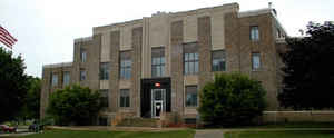
Bremer County is a county located in the state of Iowa. Based on the 2010 census, the
population was 24,276. Bremer County was
created on January 15, 1851. The county
seat is Waverly.
The county was named for Fredrika Bremer, a Swedish traveler, poet, and author.
Bremer County is included in the Waterloo-Cedar Falls, IA Metropolitan Statistical Area
Etymology - Origin of Bremer County Name
Bremer County is named for Fredricka Bremer, a Swedish novelist. (Unique county name)
Demographics:
County QuickFacts: CensusBureau Quick Facts
BremerCounty History
The first white man came to Bremer
County in 1845 and settled about two miles southwest of Denver. At that time
this area was an Indian reservation belonging to the Winnebagoes, numbering
about 300. Later the Reservation was purchased by the government, and the
Indians were moved to the Crow River area of Minnesota, about 150 miles north of
St. Paul.
Bremer County had been named in 1851 by Governor Hempstead, who was an admirer
of the Swedish authoress, Fredricka Bremer. Bremer County is thought to be the
only Iowa county named after a person eminent in literature.
Townships were named for famous people also: Washington, Jefferson, Jackson and
Polk for four of our presidents; Fremont and Douglas for candidates for
president; Dayton for a presidential running mate in 1856; Lafayette and Warren
for two famous soldiers of the Revolution; Fredricka for Fredricka Bremer;
Maxfield for Judge Maxfield; and Sumner for Charles Sumner, a senator of the
Civil War period.
Waverly was first settled in 1850, and it soon grew to importance due to its
waterpower that was used by the flour and saw mills. On January 24, 1853 Waverly
was chosen as the county seat, and, unlike numerous counties the county seat has
remained unchanged. Waverly was selected because of its growth, commercial
position and railroad facilities.
Bremer County was permanently organized in August 1853 with the election of
county officers.
The first courthouse was erected one year later by Richard Miles at a cost of
$147.50. The small frame building was used for only three years, and then it was
replaced by a brick and stone two-story structure that cost the county $23,000
to complete. None of the materials used in its construction - brick, stone and
lumber - were from outside of the county. This 43-foot x 63-foot building was
dedicated on January 1, 1858 at a grand ball and reception that was held in the
new building.
This second courthouse contained no vaults for the safekeeping of county
records, so in the summer of 1870 a small brick building was constructed
adjacent to the courthouse. The $5,000 building was used to house all of the
county records.
These two buildings were torn down in 1937 in order to make room for the third
and present courthouse. The county used a W.P.A. grant of more than $60,000 to
construct a $139,000 courthouse. Several bands were on hand to celebrate the
dedication and open house of the courthouse on June 10, 1937.
On July 2, 1975, a joint law enforcement building was erected to be shared by
Waverly Police and Bremer County Sheriff Department. At this time the Sheriff's
housing quarters, office and jail were removed from the courthouse building.
In 2003 Bremer County will be celebrating it's 150th year from the election of
county officers. The courthouse is in the process of going through a renovation
project and will be completed by 2003.
Sources:
1965 Bremer County Atlas
Kathy Thoms, Bremer County Director of Finance & Management, 2002
Geography: Land and Water
As reported by the Census Bureau, the county has a total area of 439 square miles (1,140 km2), of which 435 square miles (1,130 km2) is land and 3.9 square miles (10 km2) (0.9%) is water.
Bremer county is located in northeast Iowa. The county is
crossed by the Cedar and Wapsipinicon rivers.
Neighboring Counties
Bordering counties are as follows:
- North: Chickasaw County
- East: Fayette County
- Southeast: Buchanan County
- South: Black Hawk County
- West: Butler County
- Northwest: Floyd County
Education
Wartburg College is located in Waverly.


Click Image to Enlarge
