


Click Image to Enlarge
Iowa Counties
There are ninety-nine counties in Iowa. The first two counties, Des Moines County and Dubuque County, were created in 1834 when Iowa was still part of the Michigan Territory. In preparation for Michigan's statehood, part of Michigan Territory was formed into Wisconsin Territory in 1836]. Two years later, the western portion was split off to become Iowa Territory. The south-eastern part of Iowa Territory became Iowa, the 29th state in the union, on 28 December 1846, by which point 44 Counties had been created. Counties continued to be created by the state government until 1857, when the last county, Humboldt County, was created.Buchanan County, Iowa
Buchanan County Education, Geography, and History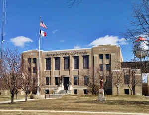
Buchanan County is a county located in the state of Iowa. Based on the 2010 census, the population was 20,958. The county was created in 1837. The county seat is Independence. Buchanan county is named in honor of Senator James Buchanan, the 15th President of the United States.
Etymology - Origin of Buchanan County Name
Buchanan county is named for James Buchanan, the fifteenth president of the United States.
Demographics:
County QuickFacts: CensusBureau Quick Facts
Buchanan County History
The county was established in 1839.
Buchanan County was a land ruled by Indian tribes in 1842 when a pioneer named
William Bennett trekked westward from Delaware County to become the first
settler in this region. As the county's first settler, he also became the first
resident of Quasqueton.
Buchanan County was named in honor of Senator James Buchanan of Pennsylvania,
who was instrumental in the acquisition of the Wisconsin Territory, which
included this county. The Senator later became the 15th president of the United
States.
A village of fewer than 15 persons located farther north of Quasqueton on the
Wapsipinicon River was established as the county seat in 1846 by three
distinguished guests from the Iowa Legislature. At the same time, the settlement
was named "Independence," probably taking the name from Independence Day, which
was to be observed by the nation in 19 days. The town was incorporated in 1864.
In the spring of 1857, the construction of the first courthouse was started by
Oliver Harrison Pierce Roszell, then the county judge, who had control of county
business at that time. The office of county judge in 1857 would be similar to
the present-day county auditor's position. The task of completing the building
fell to Judge Stephen Tabor, who, in 1857, was appointed to succeed Roszell as
county judge. The cost of $9,758.51 comprised all that had been done for the
courthouse, including the preparing of the ground, the lumber (which was hauled
from Dyersville by ox teams), the lime, stone, brick, sand, hardware, well, and,
in fact, every species of expense connected with the grounds of the edifice.
Two men were convicted of blowing up the treasurer's safe and stealing $26,000
from Buchanan County. This was one of the largest robberies in Iowa's early
history. They were pardoned because of inconclusive evidence of guilt. One of
the men moved to Kansas and was later elected to the Kansas State Legislature.
In 1870, by a vote of 1,405 to 264, the old jail and sheriff's house was built
at a cost of $18,828. In 1881, by a vote of 2,155 to 615, a fireproof building
was erected by expending $7,500 from the swamp fund.
By 1938, there was a need for a new and larger courthouse. The voters agreed,
2,665 to 1,756, on the condition that the county by permitted to issue bonds and
to ask the federal government for a grant. The first shovel of dirt was moved
November 15, 1938, by Wilbert H. Frye, chairman of the Board of Supervisors at
that time. Bonds were sold to the county for $110,000 at 1.75 percent interest,
and $114,264.45 was received from the federal government. Total cost of the
building was $253,921. The cornerstone was laid September 20, 1939, with 1,500
people present.
In 1976, the Buchanan-Independence Public Safety Center was constructed for
joint use by the Independence Police Department and the Buchanan County
Sheriff's Department.
Geography: Land and Water
As reported by the Census Bureau, the county has a total area of 573 square miles (1,480 km2), of which 571 square miles (1,480 km2) is land and 2.1 square miles (5.4 km2) (0.4%) is water.
Bremer county is located in northeast Iowa. The Wapsipinicon River is
located in this county.
Neighboring Counties
Bordering counties are as follows:
- North: Fayette County
- Northeast: Clayton County
- East: Delaware County
- Southeast: Linn County
- Southwest: Benton County
- West: Black Hawk County
- Northwest: Bremer County
Education


Click Image to Enlarge
