


Click Image to Enlarge
Iowa Counties
There are ninety-nine counties in Iowa. The first two counties, Des Moines County and Dubuque County, were created in 1834 when Iowa was still part of the Michigan Territory. In preparation for Michigan's statehood, part of Michigan Territory was formed into Wisconsin Territory in 1836]. Two years later, the western portion was split off to become Iowa Territory. The south-eastern part of Iowa Territory became Iowa, the 29th state in the union, on 28 December 1846, by which point 44 Counties had been created. Counties continued to be created by the state government until 1857, when the last county, Humboldt County, was created.Cerro Gordo County, Iowa
Cerro Gordo County Education, Geography, and History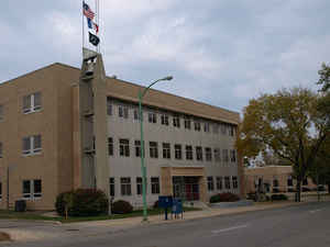
Cerro Gordo County is a county located in the state of Iowa. Based on the 2010 census, the
population was 44,151. Cerro Gordo County was
created in 1851. The county seat is
Mason City. The county is named for the Battle of Cerro Gordo, which took place during the Mexican-American War.
Cerro Gordo County is part of the Mason City, IA Micropolitan Statistical Area.
Etymology - Origin of Cerro Gordo County Name
Cerro Gordo county is named for the Battle of Cerro Gordo in the Mexican-American War.
Demographics:
County QuickFacts: CensusBureau Quick Facts
Cerro Gordo County History
Cerro Gordo County is named after the
location of a battle in the Mexican War. At this site General Winfield Scott
defeated General Santa Ana of the Mexican army on April 18, 1847.
In 1851 the first white settlers came to the county, settling at Clear Lake.
Four years later, August 7, 1855, the first county elections were held. Closely
following these elections was the appointment of three locating commissioners.
These commissioners located the county seat at Mason City, which was first
called Shibboleth and later Masonic Grove.
The first court was held in Mason City in 1857. It was short-lived because in
the summer of 1857 the county seat was moved to Livonia. A new courthouse was
built there, and the county records and offices were soon located at this small
town. This too was short-lived, because in April, 1858, Mason City won back the
county seat in an election. Following this the county erected a $600 stone
courthouse in Mason City. Built in 1866, this building was used until 1900, when
it was abandoned. In 1902 a second courthouse of native stone was completed.
Like its predecessor, it lasted a long time - from 1902 until 1960 when it was
torn down.
The present Cerro Gordo courthouse was first used on November 17, 1960. The
building, purchased from the Standard Oil Company, was remodeled, and an
addition was completed at that time to make a 49,000 square-foot building. That
$750,000 project was financed through a bond. There was another addition in 1978
to create the current building as it stands now.
In 1999 the county purchased a building located on the block across the street
from the current courthouse. This became known as the Cerro Gordo County
Sheriff's Department Annex. The Department began housing prisoners in the annex
in June 2000.
Source: Colleen Pearce, Cerro Gordo County Recorder, 2002
Geography: Land and Water
As reported by the Census Bureau, the county has a total area of 575 square miles (1,490 km2), of which 568 square miles (1,470 km2) is land and 6.8 square miles (18 km2) (1.2%) is water.
Cerro Gordo county is located in north Iowa.
Neighboring Counties
Bordering counties are as follows:
- North: Worth County
- Northeast: Mitchell County
- East: Floyd County
- Southeast: Butler County
- South: Franklin County
- Southwest: Wright County
- West: Hancock County
- Northwest: Winnebago County
Education


Click Image to Enlarge
