


Click Image to Enlarge
Iowa Counties
There are ninety-nine counties in Iowa. The first two counties, Des Moines County and Dubuque County, were created in 1834 when Iowa was still part of the Michigan Territory. In preparation for Michigan's statehood, part of Michigan Territory was formed into Wisconsin Territory in 1836]. Two years later, the western portion was split off to become Iowa Territory. The south-eastern part of Iowa Territory became Iowa, the 29th state in the union, on 28 December 1846, by which point 44 Counties had been created. Counties continued to be created by the state government until 1857, when the last county, Humboldt County, was created.Fayette County, Iowa
Fayette County Education, Geography, and History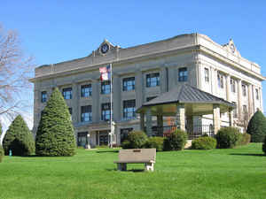
Fayette County is a county located in the state of Iowa. Based on the 2010 census, the population was 20,880. Fayette County was created on December 21, 1837. The county seat is West Union. The county is named in honor of Marie-Joseph-Paul-Roch-Yves-Gilbert Du Motier, Marquis de La Fayette, the French general in the American Revolutionary War.
Etymology - Origin of Fayette County Name
Fayette county is named for Marie-Joseph-Paul-Roch-Yves-Gilbert Du Motier, Marquis de La Fayette, the French general in the American Revolutionary War.
Demographics:
County QuickFacts: CensusBureau Quick Facts
Fayette County History
Fayette County was originally one of
the largest counties ever organized. It had an area of about 140,000 square
miles and included all of the present state of Minnesota west of the
Mississippi. Almost all of the counties of northeastern Iowa were formed out of
this county. The county was established in 1837. Fayette County, as large as it
was, was only a "paper county" and lacked any organization until 1847 when it
was reduced to its present boundaries. The county is named in honor of Marquies
de Lafayette, a French general and statesman who helped the American Colonies in
the Revolutionary War.
In 1850 William Wells, Jacob Lybrand, and J.W. Rogers donated a 400-square-foot
plot of ground to Fayette County for public buildings. That was the year the
county was organized. Until that time, West Union was known as Knob Prairie.
In 1851 a Fayette County Representative drafted a bill at the Third General
Assembly that called for an election to choose a site for the county seat. They
had six choices: West Union, Lightville (Lima), Light's Mill, Douglas (Auburn),
Centerville, and Clermont.
The two highest vote-getters then participated in a May election. The voters
chose West Union over Lightville. But before a courthouse could be built a vote
was taken in August 1853 to remove the county seat. West Union again won the
right to house the county seat.
Although a courthouse was proposed in 1853 one was not built until three years
later. Business of the county was conducted in the Methodist Church. When a
courthouse was finally built, it cost $7,820. The two-story brick and stone
building was situated on that town square donated by Wells. This building burned
to the ground after J. C. Thompson started a fire in his jail cell, which was in
the basement of the courthouse. He escaped and was later captured in Calmar.
After a two-year battle for the location of the courthouse, a second building
was built in West Union. Originally to cost only $6,750, it ended up costing the
county around $10,000. The call for a fireproof building in September 1891
failed, and gradual improvements were then added to the second courthouse. They
included fire-safe vaults, a larger heating plant, a tower, a clock, and more
office space. This was over a period of 15 years and cost more than $18,000.
The improvements were all for naught because this building was also destroyed by
a fire on February 5, 1922. The estimated loss was $40,000, only $24,000 covered
by insurance. Most of the county records were saved. This fire again opened the
battle for the county seat. The rivals this time were Fayette and Oelwein. Again
West Union prevailed and a third, and current, courthouse was built.
The citizens of West Union and surrounding areas donated $100,000 toward the new
structure. The cornerstone was laid on June 21, 1923, and the formal dedication
was held on October 8, 1924. Total cost of the majestic gray Bedford stone
structure was $298,690.
Sources:
History of West Union, Iowa. 1974, (125th jubilee),
Out of the Midwest: A Portrait, 1976, Fayette County Helpers Club and Historical
Society
Geography: Land and Water
As reported by the Census Bureau, the county has a total area of 731 square miles (1,890 km2), of which 731 square miles (1,890 km2) is land and 0.5 square miles (1.3 km2) (0.07%) is water.
Fayette county is located in northeast Iowa.
Neighboring Counties
Bordering counties are as follows:
- North: Winneshiek County
- Northeast: Allamakee County
- East: Clayton County
- Southeast: Delaware County
- South: Buchanan County
- Southwest: Black Hawk County
- West: Bremer County
- Northwest: Chickasaw County
Education


Click Image to Enlarge
