


Click Image to Enlarge
Iowa Counties
There are ninety-nine counties in Iowa. The first two counties, Des Moines County and Dubuque County, were created in 1834 when Iowa was still part of the Michigan Territory. In preparation for Michigan's statehood, part of Michigan Territory was formed into Wisconsin Territory in 1836]. Two years later, the western portion was split off to become Iowa Territory. The south-eastern part of Iowa Territory became Iowa, the 29th state in the union, on 28 December 1846, by which point 44 Counties had been created. Counties continued to be created by the state government until 1857, when the last county, Humboldt County, was created.Hardin County, Iowa
Hardin County Education, Geography, and History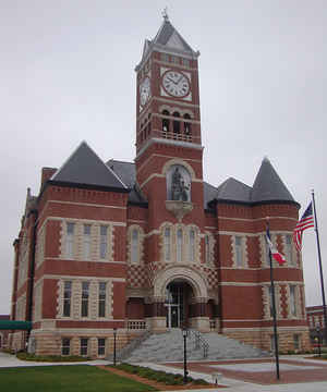
Hardin County is a county located in the state of Iowa. Based on the 2010 census, the population was 17,534. Hardin County was created on January 15, 1851. The county seat is Eldora. The county is named in honor of Colonel John J. Hardin, of Illinois, who was killed in the Mexican-American War.
Etymology - Origin of Hardin County Name
Hardin county is named for Colonel John J. Hardin, a soldier in the Black Hawk War and Mexican-American War in which he lost his life.
Demographics:
County QuickFacts: CensusBureau Quick Facts
Hardin County History
Hardin County is named after Colonel
John J. Hardin. He was a Illinois colonel in the Black Hawk War and was killed
in the Mexican War.
The county was established in 1851. After the county was organized in 1853, a
county seat was needed, and Judge William McKay of the Fifth Judicial District
appointed two men to locate a suitable site. In late June, 1853 they selected a
site and asked Mrs. S. R. Edington to name the town. She chose the name Eldora,
after a baby she had just lost.
The county seat has been in Eldora since 1853, but this does not mean that it
has been without conflict. The first contest was by the town of Steamboat Rock.
An election was held in April 1856, and Steamboat Rock was defeated by a vote of
452 to 100.
After a small challenge by the village of Berlin in 1857, it was Point
Pleasant's turn. This election was held in April of 1858 and was hotly contested
throughout the county. When it was over Point Pleasant was the winner, 540 to
521. The battle did not stop there, however. After the votes from Point Pleasant
were counted, sealed, and delivered, someone broke into the contents and
destroyed them. Point Pleasant blamed Eldora, and Eldora blamed Point Pleasant.
Both went to court, and, after a 10-year battle, which included three Supreme
Court decisions, Eldora emerged victorious.
The final battle came from Iowa Falls. It came at a time when Eldora was in the
process of building the present courthouse. Iowa Falls citizens offered the
county $32,000 towards a new courthouse if they built it in Iowa Falls. The
citizens of Eldora then donated $40,000. When added to the $20,000 already
appropriated, it made quite a sum towards a new courthouse.
Through four contests from 1856 to 1891 - not to mention all the legal battles
that resulted from the competitions - Eldora has retained the designation as
the seat of justice for Hardin County. And so it has remained for more than 139
years.
Hardin County has had three courthouses in its history. The first building was a
small frame structure and was used until it burned in the mid-1850s.
The second courthouse was built with funds donated by the citizens of Eldora and
$1,000 of county funds. It was a two-story frame building and was located on the
present site of the county sheriff's office.
The last and present courthouse was built in 1892 and was ready for operation on
September 19, 1893. The contractor was J. F. Atkinson, and total cost was
$75,000. In 1970-71 the courthouse underwent major remodeling, at a cost of
$365,000. It was paid for by a bond issue. After it was completed the citizens,
donated money for landscaping of the courthouse grounds.
The Hardin County courthouse was placed on the National Register of Historic
Places in 1981. It still stands as a monument to the pride which rural Iowans
have always had in their communities.
Source: Keith Van Patter, Hardin County Recorder
Geography: Land and Water
As reported by the Census Bureau, the county has a total area of 570 square miles (1,500 km2), of which 569 square miles (1,470 km2) is land and 0.7 square miles (1.8 km2) (0.1%) is water.
Hardin county is located close to the center of Iowa. Pine Lake State
Park is located in this county.
Neighboring Counties
Bordering counties are as follows:
- North: Franklin County
- Northeast: Butler County
- East: Grundy County
- Southeast: Marshall County
- Southwest: Story County
- West: Hamilton County
- Northwest: Wright County
Education


Click Image to Enlarge
