


Click Image to Enlarge
Iowa Counties
There are ninety-nine counties in Iowa. The first two counties, Des Moines County and Dubuque County, were created in 1834 when Iowa was still part of the Michigan Territory. In preparation for Michigan's statehood, part of Michigan Territory was formed into Wisconsin Territory in 1836]. Two years later, the western portion was split off to become Iowa Territory. The south-eastern part of Iowa Territory became Iowa, the 29th state in the union, on 28 December 1846, by which point 44 Counties had been created. Counties continued to be created by the state government until 1857, when the last county, Humboldt County, was created.Jackson County, Iowa
Jackson County Education, Geography, and History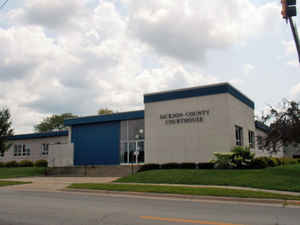
Jackson County is a county located in the state of Iowa. Based on the 2010 census, the population was 19,848.The county was created on December 21, 1837. The county seat is Maquoketa. Jackson county is named after United States President Andrew Jackson.
Etymology - Origin of Jackson County Name
Jackson county is named for Andrew Jackson, the seventh president of the United States.
Demographics:
County QuickFacts: CensusBureau Quick Facts
Jackson County History
Jackson County, located in eastern
Iowa along the Mississippi River, is named in honor of Andrew Jackson, the
seventh president of the United States.
When Jackson, Jones, and Linn counties were first established in 1837, Bellvue
(sometimes spelled Belleview, Bellview, or Bellevue) was the seat of justice for
all three. It was named in honor of John D. Bell, an early resident and
postmaster of the county. The county commissioners met for the first time on
April 2, 1838. At this time Bellvue was the only town of significance and
therefore the logical choice for a county seat.
A one mill tax was levied by the commissioners for the county fund and a
one-half mill tax for the court fund. Since money was scarce, payments in
commodities, such as coonskins and maple sugar were accepted for tax payments.
When Iowa became an official territory on July 4, 1838, the Territorial Assembly
set up a procedure to locate a new county seat that was more centrally located.
The locating commissioners chose the town of Andrew as the new county seat. An
election was then held between the towns of Bellvue and Andrew. Andrew was
declared the winner.
The first actual county courthouse for Jackson County was built at Andrew. It
was a log cabin that measured 30 feet x 40 feet. This structure was used until
1848 when the county seat was then moved back to Bellvue. A brick structure had
been built at Bellvue, and it served the county until 1861. At this time the
county seat was moved back to Andrew.
In 1861 the town of Andrew built its second courthouse. The building cost the
town $6,000, and it was offered to the county rent-free for five years. In 1866
the county purchased the building for $2,000. The three-story stone structure
served the county for 12 years, and then it was sold to the Andrew Cooperative
Creamery Company.
In 1873 the county seat battles that were abundant in the early 1800s came to an
end. The railroad had come to the town of Maquoketa, and the population of the
town had grown substantially. The city council built a large "city hall" at a
cost of $14,000. The size of the building was 45-foot x 81-foot and was
constructed of dressed stone. The county signed a 99 year lease that committed
it to the building and the town for $1.
In 1938 the courthouse had been outgrown, so much so that some of the county
offices were in other buildings. In 1958, the county corrected this problem. A
$400,000 one-story structure was constructed on the site of the previous
courthouse. The architect was William J. McNeil, and the contractor was Roth &
Associates. The county moved into the building on January 1, 1961.
Sources:
Jackson County Directory, 1878
Mike Cotton, Jackson County Auditor, 2002
Geography: Land and Water
As reported by the Census Bureau, the county has a total area of 650 square miles (1,700 km2), of which 636 square miles (1,650 km2) is land and 14 square miles (36 km2) (2.1%) is water.
Jackson county is located in east Iowa. The county's eastern border is formed by the Mississippi River.
Neighboring Counties
Bordering counties are as follows:
- Northeast: Jo Daviess County, Ill.
- East: Carroll County, Ill.
- South: Clinton County
- West: Jones County
- Northwest: Dubuque County
Education


Click Image to Enlarge
