


Click Image to Enlarge
Iowa Counties
There are ninety-nine counties in Iowa. The first two counties, Des Moines County and Dubuque County, were created in 1834 when Iowa was still part of the Michigan Territory. In preparation for Michigan's statehood, part of Michigan Territory was formed into Wisconsin Territory in 1836]. Two years later, the western portion was split off to become Iowa Territory. The south-eastern part of Iowa Territory became Iowa, the 29th state in the union, on 28 December 1846, by which point 44 Counties had been created. Counties continued to be created by the state government until 1857, when the last county, Humboldt County, was created.Polk County, Iowa
Polk County Education, Geography, and History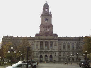
Polk County is a county located in the state of Iowa. Based on the 2010 census, the
population was 430,640, making it the most populous
county in Iowa. Polk County was created on January 13,
1846. The county seat is Des Moines, which is also the capital city of Iowa.
The county is named in honor of James Knox Polk
(1795–1849), the eleventh president of the United States.
Polk County is included the Des Moines-West Des Moines, IA Metropolitan Statistical Area
Etymology - Origin of Polk County Name
Polk county is named for James Knox Polk, the eleventh president of the United States.
Demographics:
County QuickFacts: CensusBureau Quick Facts
Polk County History
Polk County is named for the 11th
president of the United States, James K. Polk. The county was formally organized
on January 17, 1846.
May 1843 saw the arrival of Captain James Allen and his company at the present
site of Des Moines. He proposed the name of Fort Raccoon but used Fort Des
Moines at the suggestion of General Winfield Scott. The term "des moines" refers
to the principal river between the Mississippi and Missouri Rivers. Soon a fort
was erected that consisted of 25 buildings, which included stables and a
barracks. A trading post was built by Indian traders George Washington and
Washington George Ewing. It was erected across the river.
The towns of Brooklyn, Polk City, Dudley, and Fort Des Moines competed for the
county seat. They all sent representatives to the Iowa Territorial Legislature
in 1845 to lobby the legislators to establish the boundaries of Polk County.
On January 13, 1845 the Legislature passed an Act establishing the boundaries of
Polk County. The delegation from Brooklyn returned home confident that they had
captured the county seat. The delegation from Fort Des Moines had other plans,
however. Four days later they succeeded in securing an amendment to a
supplementary bill that altered the boundaries of Polk County once more. This
was done so that Fort Des Moines would be nearer to the geographical center than
Brooklyn. It was accomplished by "borrowing" 144 square miles of territory from
Warren County.
Three commissioners were appointed to establish the county seat. Since Fort Des
Moines was centrally located, it was chosen as the county seat on May 25, 1846.
The town of Brooklyn is now part of Des Moines.
In 1849, when Warren County was organized, the residents of Warren County
ordered the land "borrowed" by Polk County returned. In 1853 the Legislature did
just that, except for a few sections in Camp Township.
The first courthouse was built by John Saylor in 1846. The two story structure,
complete with cellar, cost $2,015 and was used for ten years.
Construction on a second courthouse was begun in 1858. Due to slow construction
and the Civil War the building was not completed and operational until October
1866. Around 1887-1888 a new roof, cupola and wing were added. Total cost was
estimated at $103,268. This courthouse was used for 40 years.
The present courthouse was erected in 1900 at a cost of $750,000. It was
designed by George W. Bird and W. T. Proudfoot in a modified Renaissance style.
It was officially dedicated on October 31, 1906. In 1962, $220,000 was used for
remodeling of the courthouse. This, however, was not enough to alleviate the
problems of overcrowding.
In 1975 the voters approved spending $5.8 million to purchase and renovate the
old US Post Office.
The auditor, recorder, treasurer, board of supervisors, and personnel and
general services departments are all housed in this building. Long range plans
for the courthouse have been started. They include extensive remodeling at an
estimated cost of $6 million.
Geography: Land and Water
As reported by the Census Bureau, the county has a total area of 592 square miles (1,530 km2), of which 574 square miles (1,490 km2) is land and 18 square miles (47 km2) (3.0%) is water.
Polk county is located close to the center of Iowa. The county is bisected by the Des Moines River.
Neighboring Counties
Bordering counties are as follows:
- North: Story County
- East: Jasper County
- Southeast: Marion County
- South: Warren County
- Southwest: Madison County
- West: Dallas County
- Northwest: Boone County
Education


Click Image to Enlarge
