


Click Image to Enlarge
Iowa Counties
There are ninety-nine counties in Iowa. The first two counties, Des Moines County and Dubuque County, were created in 1834 when Iowa was still part of the Michigan Territory. In preparation for Michigan's statehood, part of Michigan Territory was formed into Wisconsin Territory in 1836]. Two years later, the western portion was split off to become Iowa Territory. The south-eastern part of Iowa Territory became Iowa, the 29th state in the union, on 28 December 1846, by which point 44 Counties had been created. Counties continued to be created by the state government until 1857, when the last county, Humboldt County, was created.Poweshiek County, Iowa
Poweshiek County Education, Geography, and History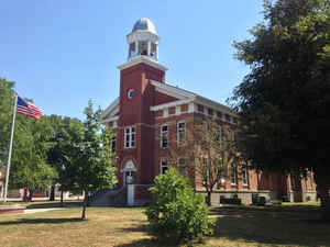
Poweshiek County is a county located in southeastern part of the state of Iowa. Based on the 2010 census, the population was 18,914. Poweshiek County was created on February 17, 1843. The county seat is Montezuma. The county is named for the Indian chief of the Fox tribe who signed the treaty ending the Black Hawk War.
Etymology - Origin of Poweshiek County Name
Poweshiek county is named for Poweshiek, a Fox chief that supported peace in the Black Hawk War.
Demographics:
County QuickFacts: CensusBureau Quick Facts
Poweshiek County History
The county was originally part of the
county of Keokuk from 1837 to 1840 and was subsequently attached at different
times to both Iowa and Mahaska counties. The county is named in honor of Chief
Poweshiek, Fox-Mesquaki Indian Chief, who was for peace in the Black Hawk War.
The present area of the county was said to be the hunting and fishing grounds
for Chief Poweshiek.
The first settler in Poweshiek County, after the Indians departed, was Richard
B. Ogden who came in the fall of 1843. The county was formally organized on
April 3, 1848, the date on which the first election was conducted. David
Edmundson, John White, and John Rose, residents of the counties of Jasper,
Mhaska, and Polk, were appointed commissioners for the purpose of locating a
site for the county seat and providing for its establishment.
Montezuma, the county seat, was laid out in June 1848. Early history says that
in the settling of the county, it was thought that the northern part of the
county would never be occupied. Therefore there was no difficulty in locating
the county seat in the central township of the southern tier of the county.
The first courthouse was built in Montezuma in 1850. The courthouse was a
two-story wooden structure with the courtroom on the first floor and the offices
of the judge, clerk, sheriff and the treasurer on the second floor. A woodcut of
the building shows that an outside stairway connected the two floors. This
building was used as a courthouse, school, church, and a social gathering place
until 1857. In 1857 the construction of the county's second and current
courthouse was begun, thus making it one of the oldest courthouses in Iowa. A
property tax of one mill on the dollar was levied to pay for the building.
The newly constructed building was only the second permanent courthouse
structure to be built in the state and is considered by the State Historical
Society to be one of the finest examples of early courthouse architecture.
The total cost of this courthouse was $21,928.15. It is constructed of brick and
its foundation, caps and sills are of limestone. Over the years the building has
undergone several changes. In 1890 an addition was completed, and in 1933-1934
the courthouse was raised, and a full basement and new foundation were
completed. This project cost approximately $15,000 to complete.
The county is located along Interstate 80, between Des Moines and Iowa City.
Geography: Land and Water
As reported by the Census Bureau, the county has a total area of 586 square miles (1,520 km2), of which 585 square miles (1,520 km2) is land and 1.1 square miles (2.8 km2) (0.2%) is water.
Poweshiek county is located close to the center of Iowa.The
county is drained by the north fork of Skunk River, which crosses the southwest corner, and
by English River and other streams.
Neighboring Counties
Bordering counties are as follows:
- North: Tama County
- Northeast: Benton County
- East: Iowa County
- Southeast: Keokuk County
- South: Mahaska County
- West: Jasper County
- Northwest: Marshall County
Education


Click Image to Enlarge
