


Click Image to Enlarge
Kansas Counties
Kansas has one hundred and five counties. Originally 33 counties were organized by the Territorial Legislature in 1855. The Chase County Courthouse in Cottonwood Falls, Kansas was built in 1873 and is the oldest operating courthouse in Kansas. As of January 1, 2009 Greeley County and the city of Tribune unified to form the Unified Government of Greeley County..Crawford County, Kansas
Crawford County Education, Geography, and History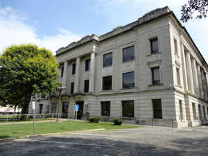
Crawford County is a county located in Southeast Kansas. Based on the 2010 census, the county
population was 39,134. Crawford County was
created on February 13, 1867. The county
seat is Girard, and its most populous city is Pittsburg. The county
is named in honor of Samuel J. Crawford, Governor of Kansas.
The Pittsburg Micropolitan Statistical Area includes all of Crawford County.
Located in the Osage Cuestas and Cherokee Lowlands, it lies halfway between Kansas City, Missouri and Tulsa, Oklahoma.
Etymology - Origin of Crawford County Name
The county was named in honor of Samuel J. Crawford who was elected Governor in 1864, and served nearly four years. The Legislature named the county in obedience to a resolution passed in convention, held to petition for its organization. Governor Crawford resigned in October, 1868, to become Colonel of the Nineteenth Kansas Cavalry, specially raised to for the Indian War of 1868-69. He served as Captain in the Second Kansas Infantry, and was Colonel of the Second Kansas Regiment Colored Volunteer Infantry during the war for the Union
Demographics:
County QuickFacts: CensusBureau Quick Facts
Crawford County History
This county was, by act of the legislature of 1867, created out of the northern half of Cherokee, which prior to that date reached to Bourbon.
Crawford County, one of the eastern tier and the second north of the line separating Kansas and Oklahoma, is bounded on the north by Bourbon county; on the east by the State of Missouri; on the south by Cherokee county, and on the west by the counties of Neosho and Labette. It was created by the act of Feb. 13, 1867, and was named for Col. Samuel J. Crawford, at that time the governor of Kansas. The area of the county is 592 square miles. It is divided into nine townships, to-wit: Baker, Crawford, Grant, Lincoln, Osage, Sheridan, Sherman, Walnut and Washington.
Geography: Land and Water
As reported by the Census Bureau, the county has a total area of 595 square miles (1,540 km2), of which 590 square miles (1,500 km2) is land and 5.3 square miles (14 km2) (0.9%) is water.
Crawford county is located in east Kansas. The county is rolling prairie, the water-courses flowing in three different directions. In the northeast Drywood, Bone and Coxes creeks flow northward to the Marmaton river; in the west Big and Little Walnut and Hickory creeks flow southwest to the Neosho; and in the southeast Lightning, Lime and Cow creeks flow southward, their waters finally reaching the Neosho.
Coal of fine quality underlies the entire county, some of the veins running five feet or more in thickness. More than half the coal mined in the state comes from this county. Building stone, cement rock, fire and potter's clay of excellent quality are abundant in several localities and though only partially developed are a source of income to the owners of the deposits. The varies types of timber are oak, walnut, poplar, hickory and cottonwood.
Neighboring Counties
Bordering counties are as follows:
- North: Bourbon County
- Northeast: Vernon County, Mo.
- East: Barton County, Mo.
- Southeast: Jasper County, Mo.
- South: Cherokee County
- Southwest: Labette County
- West: Neosho County
Education
Unified School Districts
- Northeast USD 246 - Serves the northeast portion of Crawford County, namely Lincoln and Washington Townships, including the towns of Arcadia, Arma, Cockerall, Camp 50, Franklin, Mulberry and Breezy Hill. Mascot - Vikings Colors - Burgundy and White
- Southeast USD 247 - Serves primarily portions of Crawford and Cherokee counties, but also includes small portions of Labette and Neosho counties. The 300-square-mile (780 km2) district serves over 800 students in grades Pre-K through 12. Southeast High School (the "Lancers") is located just west of the city of Cherokee (the district office is located in the Cherokee/McCune Township). In Crawford County the district also serves the city of McCune. Mascot - Lancers Colors - Columbia Blue and White
- Girard USD 248 - Serves Girard and the Girard Township, including the towns of Farlington, Walnut, Greenbush and Hepler. Mascot - Trojans Colors - Maroon and Yellow/Gold
- Frontenac USD 249 - Serves Frontenac and the Frontenac Township, including the towns of Yale, Radley, Ringo and Mindenmines, Missouri. Mascot - Raiders Colors - Black and White/Silver
- Pittsburg USD 250 - Serves Pittsburg and the Pittsburg Township, including the towns of Chicopee, Opolis, and Asbury, Missouri. Mascot - Purple Dragons Colors - Purple and White
Private schools
Saint Mary's - Colgan (Web site) is a private Catholic K-12 school located in Pittsburg. Mascot - Panthers Colors - Blue and White
Higher education
Pittsburg State University is located in Pittsburg.


Click Image to Enlarge
