


Click Image to Enlarge
Kansas Counties
Kansas has one hundred and five counties. Originally 33 counties were organized by the Territorial Legislature in 1855. The Chase County Courthouse in Cottonwood Falls, Kansas was built in 1873 and is the oldest operating courthouse in Kansas. As of January 1, 2009 Greeley County and the city of Tribune unified to form the Unified Government of Greeley County..Labette County, Kansas
Labette County Education, Geography, and History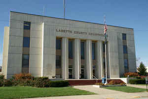
Labette County is a county located in the state of Kansas. Based on the 2010 census, the county
population was 21,607. Labette County was
created on February 26, 1867. The county
seat is Oswego, and its most populous city is Parsons.
The county is named in honor of Pierre La Bette, French
fur trapper who formed a peaceful relationship with area natives.
The Parsons, KS Micropolitan Statistical Area includes all of Labette County.
Etymology - Origin of Labette County Name
Originally part of Dorn county after Colonel Earl Van Dorn, of the regular army (he was also a Confederate officer), but changed from Dorn to Neosho in 1861 after name of the principal river in southern Kansas. Labette county has a peculiar history, not generally known, or at least not found in the books. Prior to the summer of 1866 all that part (and being the south half) of Neosho county, now comprising Labette, was sparsely populated. In the spring of 1866 there was a great rush of immigration to that locality, and the new settlers proceeded to organize a government of their own. They gave the name Labette (then written La Bette), and called a convention, nominated a full set of county officers, and a representative to the State Legislature, and elected them at the November election, and started a county government--for all of which no authority of law whatever existed. The "Representative" so elected was Charles H. Bent, who reported at Topeka with a petition, "signed by John G. Rice and 224 other citizens of Labette county," asking that Mr. Bent be admitted to a seat in the House. He was admitted, and afterwards submitted a Bill to "organize and define the boundaries of Labette county," which passed, and was approved the 7th of February, 1867. The word La Bette is French, and signifies "the beet."
Demographics:
County QuickFacts: CensusBureau Quick Facts
Labette County History
Labette County, in the southern tier, is the second county west from the Missouri line. It is bounded on the north by Neosho county, on the east by Crawford and Cherokee, on the south by the State of Oklahoma, and on the west by Montgomery county. It was established by the legislature of 1867 and the boundaries fixed to include the territory extending from the sixth standard parallel on the north to the boundary of the state on the south, and from the Cherokee neutral lands on the east to the Osage reserve on the west. Labette was formed of the southern part of Dorn county (q. v.).
Pierre Labette was an early trader in southeast Kansas; a creek was named for
him. Later, the county was named for the creek.
The early history of Labette County was marred by a mysterious and murderous
family named Bender who were never brought to justice.
Geography: Land and Water
As reported by the Census Bureau, the county has a total area of 653 square miles (1,690 km2), of which 645 square miles (1,670 km2) is land and 7.8 square miles (20 km2) (1.2%) is water.
Labette county is located in southeast Kansas. The county is generally rolling prairie, with gentle slopes, and many streams. The largest stream is the Neosho, which flows south through the eastern row of townships as far as Oswego. Labette creek rises in the northwest and flows southeast across the county. Common limestone for paving, and a superior grade of sandstone are abundant. Brick clay, coal and salt are to be had in commercial quantities. Oil and gas lie beneath almost the entire surface of the county.
Neighboring Counties
Bordering counties are as follows:
- Neosho County (north)
- Crawford County (northeast)
- Cherokee County (east)
- Craig County, Oklahoma (south)
- Nowata County, Oklahoma (southwest)
- Montgomery County (west)
Education
Unified School Districts
Cherokee USD 247 is a school district of 300 square miles (780 km2) primarily covering portions of Crawford and Cherokee counties, but also
includes small portions of Labette and Neosho counties.
Parsons USD 503
Oswego USD 504
Chetopa-St. Paul USD 505
Labette County USD 506


Click Image to Enlarge
