


Click Image to Enlarge
Kansas Counties
Kansas has one hundred and five counties. Originally 33 counties were organized by the Territorial Legislature in 1855. The Chase County Courthouse in Cottonwood Falls, Kansas was built in 1873 and is the oldest operating courthouse in Kansas. As of January 1, 2009 Greeley County and the city of Tribune unified to form the Unified Government of Greeley County..Leavenworth County, Kansas
Leavenworth County Education, Geography, and History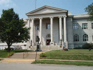
Leavenworth County is a county located in the state of Kansas. Based on the 2010 census, the county population was 76,227. Leavenworth County was created on August 25, 1855. The county seat is Leavenworth. The county is named in honor of Gen. Henry Leavenworth (1783-1834), United States Army.
The county is a part of the Kansas City, MO-KS Metropolitan Statistical Area.
Etymology - Origin of Leavenworth County Name
The county is named in honor of General Henry Leavenworth (1783-1834) United States Army. Leavenworth, directed to establish a military post on the east bank of the Missouri River near the confluence of the Little Platte, instead selected a site on high ground on the west bank to establish Cantonment Leavenworth, later renamed Fort Leavenworth.
Demographics:
County QuickFacts: CensusBureau Quick Facts
Leavenworth County History
Leavenworth County, in the northeastern part of the state, is in the third tier of counties south of Nebraska and in the first west of the Missouri river. It was erected by the first territorial legislature with the following boundaries: "Beginning at a point on the southern boundary of
Atchison county due north of a point 4 miles west of Dawson's crossing of the Fort Riley road on Stranger creek; thence due south to the main channel of the Kansas river; thence down said channel to where said channel crosses the channel of the Missouri river; thence up said channel of the
Missouri, to the southeast corner of Atchison county; thence along the southern boundary of Atchison county to the place of beginning."
As thus defined Leavenworth embraced essentially the present county and that of Wyandotte, which was detached and erected as a separate county in 1859. It was named in honor of Gen. Henry Leavenworth, an officer in the United States army. At present the county is bounded on the north by Atchison
county; on the east by Wyandotte county and the Missouri river, which separates it from Missouri; on the south by Wyandotte, Johnson and Douglas counties; and on the west by Douglas and Jefferson. It has an area of 455 square miles
Geography: Land and Water
As reported by the Census Bureau, the county has a total area of 469 square miles (1,210 km2), of which 463 square miles (1,200 km2) is land and 6.1 square miles (16 km2) (1.3%) is water.
Leavenworth county is located in east Kansas. This county is the fifth-smallest county in Kansas by total area.
This county's watershed connects with both the Kansas River basin on the south via Stranger Creek and has a Missouri River port city to the
east.
Description
Leavenworth county is located in northeast Kansas close to Kansas City. The Leavenworth Area Development LAD Corporation site has extensive information about the county.- The dome of the main building of the famous US Penitentiary - The "Big House" - can be seen for miles around. It's a very impressive building.
- Fort Leavenworth has been an active Army post since the early Nineteenth century and is the oldest Army post in continuous existence west of the Missouri River. A self-guided tour includes the Buffalo Soldier Monument and park.
From Fort Leavenworth. the most important military post in the West. It was established in 1827, and was named after Colonel Henry H. Leavenworth, of the United States Army.
In the eastern portion, along the Missouri river, the land is broken and hilly in places, but the western and southwestern portions are rolling prairie. The river and creek valleys average from a half mile to a mile and a half in width and comprise about one-fourth of the area. The uplands
are somewhat sparsely wooded and artificial groves have been planted in many places. Timber belts along the streams contain all varieties of trees native to Kansas. The principal water courses are the Missouri and Kansas rivers. The largest tributary creeks are Little Stranger, Tonganoxie, Nine
Mile, Salt, Wolf and Kaw. Leavenworth county is in the front rank in the production of Irish potatoes and sorghum. Winter wheat, corn, oats and hay are also extensively raised. There are fruit trees of bearing age in the county, and it also ranks high in live stock raising. Limestone and
sandstone for building are abundant and are extensively quarried near Leavenworth. Gray limestone is found in the bluffs and blue limestone on the lower lands. Red and yellow ocher exist south of the city of Leavenworth; in the west and southwest cement rock of a good quality is plentiful;
potter's clay is common in several localities; a great part of the county is underlaid with a bed of coal, which has for many years been mined at Leavenworth and at the state penitentiary at Lansing.
Neighboring Counties
Bordering counties are as follows:
- Platte County, Missouri (north)
- Wyandotte County (east)
- Johnson County (southeast)
- Douglas County (southwest)
- Jefferson County (west)
- Atchison County (northwest)
Education
Unified School Districts
Fort Leavenworth USD 207
Easton USD 449
Leavenworth USD 453
Basehor-Linwood USD 458
Tonganoxie USD 464
Lansing USD 469
Colleges and universities
United States Army Command and General Staff College
University of Saint Mary
Leavenworth Normal School (closed)


Click Image to Enlarge
