


Click Image to Enlarge
Kansas Counties
Kansas has one hundred and five counties. Originally 33 counties were organized by the Territorial Legislature in 1855. The Chase County Courthouse in Cottonwood Falls, Kansas was built in 1873 and is the oldest operating courthouse in Kansas. As of January 1, 2009 Greeley County and the city of Tribune unified to form the Unified Government of Greeley County..Montgomery County, Kansas
Montgomery County Education, Geography, and History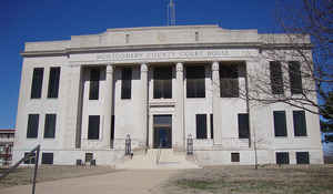
Montgomery County is a county located in the state of Kansas. Based on the 2010 census, the county
population was
35,471. Montgomery County was created on February 26,
1867. The county seat is Independence.
The county is named in honor of General Richard
Montgomery (1738-1775), a Revolutionary War hero who led the army into
Canada, capturing the city of Montreal; he died while attempting to
capture Quebec.
The Coffeyville, KS Micropolitan Statistical Area includes all of Montgomery County.
Etymology - Origin of Montgomery County Name
The county is named for General Richard Montgomery, born in Ireland, December 2, 1736; was an officer of distinction in the British Army; resigned and settled in New York State in 1773. He was appointed one of the eight generals to command the revolutionary army, in 1775; was killed in the attack on Quebec, December 31, 1775, shouting, "Death or Liberty!"
Demographics:
County QuickFacts: CensusBureau Quick Facts
Montgomery County History
Montgomery County was established February 26, 1867. It was named in honor of Richard Montgomery, an American Revolutionary War general killed in 1775 while attempting to capture Quebec City, in Canada, after successfully capturing two forts and the city of Montreal.
When Kansas was admitted to the Union as a state in 1861, the Osage Indian reservation occupied a large tract of land near the southern border. The reservation had been established in 1825. After the Civil War ended, the Osage lands were coveted as the largest and last reserve of good land in the
eastern part of the state. As early as 1866, the Osages were forced to cede tracts at the eastern and northern edges of the reservation. This treaty conceded white settlement on land in the eastern part of what is now Montgomery County. For a brief time, the Osages attempted to maintain a boundary
at the Verdigris River. The Verdigris flows from north to south through the center of Montgomery County. From the west the Elk River joins the Verdigris at a confluence slightly northwest of the geographical center of the county. In 1867 Frank and Fred Bunker established a primitive cattle camp on
the west side of the Verdigris south of the confluence. Like the Osages, the Bunkers thought they were beyond the boundaries of civilization. Early in 1869, however, settlers began to cross the Verdigris River, "at first under protest of the Indians, but the immense throng of settlers soon made all
protests futile." Montgomery County was surveyed and organized in 1869; the governor appointed commissioners June 3.
Geography: Land and Water
As reported by the Census Bureau, the county has a total area of 651 square miles (1,690 km2), of which 644 square miles (1,670 km2) is
land and 8.0 square miles (21 km2) (1.2%) is water.
Montgomery county is located in southeast Kansas. The county is prairie. The bottom lands make up 25 per cent. of the area. Timber consist of walnut, cottonwood, hickory, oak, pecan, hackberry, ash, mulberry, sycamore, elm, maple, box-elder and locust. The Verdigris river enters from the north and flows south into Oklahoma. The Elk river enters in the northwest and flowing east joins the Verdigris. The lowest point in the state of Kansas is located on the Verdigris River in Cherokee Township in Montgomery County.
Neighboring Counties
Bordering counties are as follows:
- Wilson County (north)
- Neosho County (northeast)
- Labette County (east)
- Nowata County, Oklahoma (southeast)
- Washington County, Oklahoma (south)
- Chautauqua County (west)
- Elk County (northwest)
Education
Unified School Districts
Caney Valley USD 436
Cherryvale USD 447
Coffeyville USD 445
Independence USD 446
Colleges and universities
Coffeyville Community College
Independence Community College


Click Image to Enlarge
