


Click Image to Enlarge
Kansas Counties
Kansas has one hundred and five counties. Originally 33 counties were organized by the Territorial Legislature in 1855. The Chase County Courthouse in Cottonwood Falls, Kansas was built in 1873 and is the oldest operating courthouse in Kansas. As of January 1, 2009 Greeley County and the city of Tribune unified to form the Unified Government of Greeley County..Republic County, Kansas
Republic County Education, Geography, and History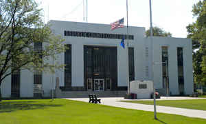
Republic County is a county located in the state of Kansas. Based on the 2010 census, the county population was 4,980. Republic County was created on February 27, 1860. The county seat is Belleville. The county is named for the Republican River, which flows through the county.
Etymology - Origin of Republic County Name
The county is named for the Republican river, which extends through the county. The river was so called because many years ago the valley of that stream was the seat of the "Pawnee Republic," a designation given to a principal division of the Pawnee Indians, or Panis, as they were originally known.
Demographics:
County QuickFacts: CensusBureau Quick Facts
Republic County History
The legislature of 1860 defined the boundaries of the county and gave it its name, taken from the Republican river, which was named from Pawnee Republic.
Republic county was organized in 1868 by proclamation of Gov. Harvey, who fixed the county seat at Pleasant Hill.
Many of the early settlers in
Republic County were from Scandinavia or Czechoslovakia. Cuba was named for Kuba,
a city in Bohemia. Scandia was settled by Swedes, and Norway by Norwegians.
The modernistic courthouse was completed in 1940
Geography: Land and Water
According to the 2000 census, the county has a total area of 720.31 square miles (1,865.6 km2), of which 716.38 square miles (1,855.4 km2) (or 99.45%) is land and 3.93 square miles (10.2 km2) (or 0.55%) is water.
Republic county is located in north Kansas. The county is rolling prairie with 10 per cent. bottom and 90 per cent. upland. The Republican river enters the county in the northwestern corner and crosses its entire width in a southerly direction; Mill and Rose creeks flow east into the Little Blue; White Rock creek flows northeast, and Beaver creek southeast into the Republican; West and Elk creeks flow south. The county has many natural springs. The mineral products are coal, limestone and salt, and the principal farm products are corn, wheat and oats.
Neighboring Counties
Bordering counties are as follows:
- Thayer County, Nebraska (north)
- Jefferson County, Nebraska (northeast)
- Washington County (east)
- Cloud County (south)
- Jewell County (west)
- Nuckolls County, Nebraska (northwest)
Education
Unified School Districts
Pike Valley USD 426
Republic County USD 109


Click Image to Enlarge
