


Click Image to Enlarge
Kentucky Counties
Kentucky has one hundred and twenty counties, third in the US behind Texas's (254) and Georgia's (159.) Washington County was the first county formed in the Commonwealth of Kentucky when it reached statehood, and the sixteenth county formedCampbell County, Kentucky
Campbell County Education, Geography, and History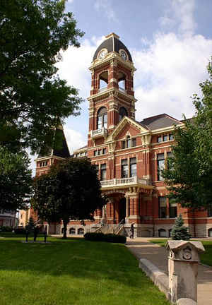
Campbell County is a county located in the state of Kentucky. Based on the 2010 census, the
population was 90,336. The county was
created on December 17, 1794. The county
seats are Alexandria and Newport. Campbell county is
named for
Colonel John Campbell (1735-1799), a Revolutionary War soldier and Kentucky legislator.
Campbell County is part of the Cincinnati-Middletown, OH-KY-IN Metropolitan Statistical Area.
Etymology - Origin of Campbell County Name
The county is named for Colonel John Campbell (1735-1799), Revolutionary War officer; founder of Louisville and a state senator.
Demographics:
County QuickFacts: CensusBureau Quick Facts
Campbell County History
Campbell County was founded December 17, 1794, two years after the creation of the Commonwealth of Kentucky, becoming the state's 19th county. Campbell County was carved out of Scott, Harrison and Mason counties. The original county included all of present Boone, Kenton, Pendleton, and most of Bracken and Grant counties. It is located in the Outer Bluegrass region of the state. The elevation in the county ranges from 455 to 920 feet above sea level. In 2000 the county population was 88,616 in a land area of 151.55 square miles, an average of 584.7 people per square mile. The county seats are Alexandria and Newport. Campbell county is in the northern Kentucky area.
The first courthouse, built of logs, was replaced in 1815 by a brick structure. The present courthouse dates from 1884.
Geography: Land and Water
As reported by the Census Bureau, the county has a total area of 159 square miles (410 km2), of which 151 square miles (390 km2) is land and 8.1 square miles (21 km2) (5.1%) is water.
Campbell county is located in northeast Kentucky. This county is the fourth-smallest county in Kentucky by land area and fifth-smallest by total area. Campbell county lies along the Ohio and Licking Rivers.
Neighboring Counties
Bordering counties are as follows:
- Northeast: Clermont County, Ohio
- South: Pendleton County
- West: Kenton County
- Northwest: Hamilton County, Ohio
Education
There are 8 school districts in Campbell County (7 Public and 1 Private). However, the Southgate Independent School District has but one PreK-8th school in it. Students in the county attend one of 6 public and 2 parochial high schools. Northern Kentucky University located in Highland Heights provides the area with access to higher education.
Public high schools
Bellevue Independent Schools, Bellevue
Campbell County Schools, Alexandria
Dayton Independent Schools, Dayton
Fort Thomas Independent Schools, Fort Thomas
Newport Independent Schools, Newport
Silver Grove Independent Schools, Silver Grove
Private high schools
Roman Catholic Diocese of Covington
Bishop Brossart High School, Alexandria
Newport Central Catholic High School, Newport


Click Image to Enlarge
