


Click Image to Enlarge
Kentucky Counties
Kentucky has one hundred and twenty counties, third in the US behind Texas's (254) and Georgia's (159.) Washington County was the first county formed in the Commonwealth of Kentucky when it reached statehood, and the sixteenth county formedGallatin County, Kentucky
Gallatin County Education, Geography, and History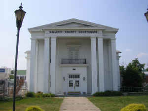
Gallatin County, is a county in the state of Kentucky. Based on the 2010 census, the
population was 8,589. Gallatin County was
created on December 14, 1798. The county
seat is Warsaw. Gallatin county is named
for Albert Gallatin, United States Secretary of the Treasury
(1801–1814).
Gallatin County is included in the Cincinnati-Middletown, OH-KY-IN
Metropolitan Statistical Area.
Etymology - Origin of Gallatin County Name
Gallatin county is named for Albert Gallatin (1761-1849), Secretary of the Treasury, and United States Minister to France and England.
Demographics:
County QuickFacts: CensusBureau Quick Facts
Gallatin County History
The county was formed on December 14, 1798. Gallatin was the 31st Kentucky county to be established. It was derived from parts of Franklin and Shelby counties. Later, parts of the county were pared off to create three additional counties: Owen in 1819, Trimble in 1836 and Carroll in 1838. Today Gallatin is one tenth of its original size. Its northern border is the Ohio River. It is located in the Outer Bluegrass region of the state. The elevation in the county ranges from 420 to 920 feet above sea level. In 2000 the county population was 7,870 in a land area of 98.81 square miles, an average of 79.6 people per square mile. The county seat is Warsaw. It is the smallest county in the state.
Geography: Land and Water
As reported by the Census Bureau, the county has a total area of 105 square miles (270 km2), of which 101 square miles (260 km2) is land and 3.5 square miles (9.1 km2) (3.3%) is water.
Gallatin county is located in north Kentucky. This county is located along the Ohio River across from Indiana and is the smallest county by area in Kentucky.
Neighboring Counties
Bordering counties are as follows:
- Northeast: Boone County
- Southeast: Grant County
- South: Owen County
- Southwest: Carroll County
- Northwest: Switzerland County, Ind.
Education


Click Image to Enlarge
