


Click Image to Enlarge
Kentucky Counties
Kentucky has one hundred and twenty counties, third in the US behind Texas's (254) and Georgia's (159.) Washington County was the first county formed in the Commonwealth of Kentucky when it reached statehood, and the sixteenth county formedGraves County, Kentucky
Graves County Education, Geography, and History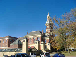
Graves County is a county located in the
state of Kentucky. Based on the 2010 census, the population was 37,121.
Graves County was created on December 19, 1821. The
county seat
is Mayfield. The county is named in honor of Benjamin
F. Graves (1771–1813), army major killed at the Battle of Frenchtown.
Graves County comprises the Mayfield, KY Micropolitan Statistical Area, which is included in the Paducah-Mayfield, KY-IL Combined Statistical
Area.
Etymology - Origin of Graves County Name
Graves County is named for Captain Benjamin Franklin Graves, who was one of numerous Kentucky officers killed after being taken as a prisoner in the disastrous 1813 Battle of Raisin River in Michigan Territory during the War of 1812. He disappeared while being forced by Potawatomi to walk to the British Fort Malden in Amherstburg, Ontario. The Indians killed prisoners who could not keep up. Nearly 400 Kentuckians died in the January 22 battle, the highest fatality of any single battle during the war.
Demographics:
County QuickFacts: CensusBureau Quick Facts
Graves County History
Graves county was formed in 1824. It is located in the Jackson Purchase region of the state. The elevation in the county ranges from 321 to 580 feet above sea level. In 2000 the county population was 37,028 in a land area of 555.59 square miles, an average of 66.6 people per square mile. The county seat is Mayfield.
Graves County is a "limited" dry county, meaning that sale of alcohol in the county is prohibited except for wine and beer in restaurants in Mayfield which have seating for at least 100 patrons or at the Mayfield Golf & Country Club.
Geography: Land and Water
As reported by the Census Bureau, the county has a total area of 557 square miles (1,440 km2), of which 552 square miles (1,430 km2) is land and 5.0 square miles (13 km2) (0.9%) is water.
Graves county is located in west Kentucky. Part of the Clarks River National Wildlife Refuge is located in this county. Graves County is made up of wandering creeks and lush pastures.
Neighboring Counties
Bordering counties are as follows:
- North: McCracken County
- Northeast: Marshall County
- Southeast: Calloway County; Henry County, Tenn.
- South: Weakley County, Tenn.
- West: Hickman County
- Northwest: Carlisle County
Education


Click Image to Enlarge
