


Click Image to Enlarge
Kentucky Counties
Kentucky has one hundred and twenty counties, third in the US behind Texas's (254) and Georgia's (159.) Washington County was the first county formed in the Commonwealth of Kentucky when it reached statehood, and the sixteenth county formedGrayson County, Kentucky
Grayson County Education, Geography, and History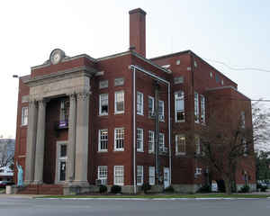
Grayson County is a county located in the state of Kentucky. Based on the 2010 census, the population was 25,746. Grayson County was created on January 25, 1810. The county seat is Leitchfield. The county is named in honor of William Grayson (1740–1790), aide to George Washington in the Revolutionary War and United States Senator from Virginia.
Etymology - Origin of Grayson County Name
Grayson county is named for Colonel William Grayson, Revolutionary War aide to General George Washington and delegate to the Virginia General Assembly and the Continental Congress.
Demographics:
County QuickFacts: CensusBureau Quick Facts
Grayson County History
Grayson County was established in 1810 from land given by Hardin and Ohio counties. It is located in the Western Coal Field region of the state. The elevation in the county ranges from 395 to 963 feet above sea level. In 2000 the county population was 24,053 in a land area of 503.68 square miles, an average of 47.8 people per square mile. The county seat is Leitchfield.
Three courthouses have been destroyed through fire; in 1864 by Confederate troops, and again in 1896 and 1936.
This county is a prohibition or dry county, though a bill was passed on March 23, 2010 to allow limited alcohol sales in restaurants
Geography: Land and Water
As reported by the Census Bureau, the county has a total area of 511 square miles (1,320 km2), of which 497 square miles (1,290 km2) is
land and 14 square miles (36 km2) (2.8%) is water.
Grayson county is located close to the center of Kentucky and is part of the Western Coal Fields region.
This county is home to two large lakes, the Rough River Lake on the
northern border of the county and Nolin River Lake in the south.
Neighboring Counties
Bordering counties are as follows:
- North: Breckinridge County
- Northeast: Hardin County
- Southeast: Hart County; Edmonson County
- Southwest: Butler County
- West: Ohio County
Education


Click Image to Enlarge
