


Click Image to Enlarge
Kentucky Counties
Kentucky has one hundred and twenty counties, third in the US behind Texas's (254) and Georgia's (159.) Washington County was the first county formed in the Commonwealth of Kentucky when it reached statehood, and the sixteenth county formedHardin County, Kentucky
Hardin County Education, Geography, and History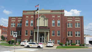
Hardin County is a county located in the state of Kentucky.
Based on the 2010 census, the population was 105,543. The county was
created December 15, 1792. The county
seat is Elizabethtown. The county is
named for Colonel John Hardin, a Continental Army officer
during the American Revolution and a brother of the Captain William
Hardin who founded Hardinsburg.
Hardin County is part of the Elizabethtown-Fort Knox, KY Metropolitan
Statistical Area, as well as the Louisville/Jefferson County-
Elizabethtown-Madison, KY-IN Combined Statistical Area.
Etymology - Origin of Hardin County Name
Hardin county is named for Colonel John Hardin (1753-1792), Revolutionary War veteran and surveyor who served with George Rogers Clark.
Demographics:
County QuickFacts: CensusBureau Quick Facts
Hardin County History
Hardin County was established in 1792 from land given by Nelson County. Hardin was the 15th Kentucky county in order of formation. It is located in the Pennyrile region of the state. The elevation in the county ranges from 383 to 1017 feet above sea level. In 2000 the county population was 94,174 in a land area of 627.98 square miles, an average of 150.0 people per square mile. The county seat is Elizabethtown.
Geography: Land and Water
As reported by the Census Bureau, the county has a total area of 630 square miles (1,600 km2), of which 623 square miles (1,610 km2) is land and 6.9 square miles (18 km2) (1.1%) is water.
Hardin county is located close to the center of Kentucky. This county is the fourth-largest county by area in Kentucky.
Neighboring Counties
Bordering counties are as follows:
- North: Harrison County, Ind.
- Northeast: Jefferson County; Bullitt County; Nelson County
- Southeast: Larue County
- South: Hart County
- Southwest: Grayson County
- West: Breckinridge County
- Northwest: Meade County
Education
Three public school districts operate in the county:
The Hardin County Schools
The Elizabethtown Independent Schools
West Point Independent School District
Five private schools also operate in the county, St. James Catholic School, Gloria Dei Lutheran School (LCMS), Elizabethtown Christian
Academy, North Hardin Christian School, and Hardin Christian Academy.


Click Image to Enlarge
